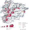
File:Miejscowości Andory.jpg
Appearance

Size of this preview: 582 × 600 pixels. Other resolutions: 233 × 240 pixels | 466 × 480 pixels | 1,005 × 1,036 pixels.
Original file (1,005 × 1,036 pixels, file size: 268 KB, MIME type: image/jpeg)
File history
Click on a date/time to view the file as it appeared at that time.
| Date/Time | Thumbnail | Dimensions | User | Comment | |
|---|---|---|---|---|---|
| current | 13:43, 24 January 2015 |  | 1,005 × 1,036 (268 KB) | Aotearoa | =={{int:filedesc}}== {{Information |description={{pl|1=Liczba ludności w miejscowościach Andory w 2013 roku (przykład mapy, na której połączono metodę kartodiagramu oraz metody jakościowe)}} |date=2015-01-24 |source=Prezentacja danych na mapach... |
File usage
The following 2 pages use this file:
Global file usage
The following other wikis use this file:
- Usage on ar.wikipedia.org
- Usage on fr.wikipedia.org
- Usage on id.wikipedia.org
- Usage on mk.wikipedia.org
- Usage on pl.wikipedia.org
- Usage on pt.wikipedia.org
- Usage on tum.wikipedia.org
- Usage on uk.wikipedia.org
- Usage on ur.wikipedia.org
- Usage on www.wikidata.org
