Jump to content

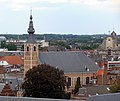
File:Mechelen Our Lady of Leliëndaal seen from Our Lady across the river Dijle.JPG

Page contents not supported in other languages.
This is a file from the Wikimedia Commons
From Wikipedia, the free encyclopedia

Original file (2,912 × 2,460 pixels, file size: 5.77 MB, MIME type: image/jpeg)

Summary

Description
Nederlands: Onze-Lieve-Vrouw van Leliëndaal, een barokke jezuïetenkerk in de Bruul te Mechelen, zoals gezien vanop de toren van Onze-Lieve-Vrouw-over-de-Dijlekerk. Rechts ziet men de Sint-Pieters- en Pauluskerk, een voormalige Jezuïetenkerk op de Veemarkt.
English: Church of Our Lady of Leliëndaal, a baroque Jesuit church in the centre of Mechelen, (Belgium), as seen from the tower of the Onze-Lieve-Vrouw-over-de-Dijlekerk (Church of Our Lady across the river Dijle). To the right Sint-Pieters- en Pauluskerk (Saint Peter's and Paul's Church), a former Jesuit Church
Français : Onze-Lieve-Vrouw van Leliëndaal, une église jesuite baroque à Malines (Flandre, Belgique), vue du Onze-Lieve-Vrouw-over-de-Dijlekerk (Eglise de Notre-Dame au dessus de la Dyle). A droite leSint-Pieters- en Pauluskerk (l'église de St-Pierre et St-Paul), une église jésuite.
Deutsch: Onze-Lieve-Vrouw van Leliëndaal, eine barocke Jesuitenkirche in Mechelen (Flandern, Belgien) wie gesehen vom Turm der Onze-Lieve-Vrouw-over-de-Dijlekerk (Liebfrauenkirche über der Dijle). Rechts seht man die Sint-Pieters- en Pauluskerk (Sankt Petri und Sankt Paul Kirche).
This is a photo of onroerend erfgoed number
3466
This is a photo of onroerend erfgoed number
3851
Date
Source Own work
Author Ad Meskens
Permission
(Reusing this file)

You are free to use this picture for any purpose as long as you credit its author, Ad Meskens.

Example: © Ad Meskens / Wikimedia Commons

If you use this work outside of the Wikimedia projects, a message or a copy is very much appreciated.

This image is not in the public domain. A statement such as "From Wikimedia Commons" or similar is not by itself sufficient. If you do not provide clear attribution to the author you do not comply with the terms of the file's license and you may not use this file. If you are unable or unwilling to provide attribution you should contact Ad Meskens to negotiate a different license.


Camera location51° 01′ 22.76″ N, 4° 28′ 42.43″ E Kartographer map based on OpenStreetMap.View this and other nearby images on: OpenStreetMapinfo

Licensing

I, the copyright holder of this work, hereby publish it under the following license:
w:en:Creative Commons
attribution share alike
This file is licensed under the Creative Commons Attribution-Share Alike 3.0 Unported license.
You are free:
  • to share – to copy, distribute and transmit the work
  • to remix – to adapt the work
Under the following conditions:
  • attribution – You must give appropriate credit, provide a link to the license, and indicate if changes were made. You may do so in any reasonable manner, but not in any way that suggests the licensor endorses you or your use.
  • share alike – If you remix, transform, or build upon the material, you must distribute your contributions under the same or compatible license as the original.

Captions

Add a one-line explanation of what this file represents

8 September 2013

51°1'22.760"N, 4°28'42.431"E

0.005 second

40.3 millimetre

image/jpeg

File history

Click on a date/time to view the file as it appeared at that time.

Date/TimeThumbnailDimensionsUserComment
current20:42, 9 September 2013Thumbnail for version as of 20:42, 9 September 20132,912 × 2,460 (5.77 MB)Ad Meskens{{Information |Description ={{en|1=aaaaaa}} |Source ={{own}} |Author =Ad Meskens |Date = |Permission = |other_versions = }}

The following page uses this file:

Global file usage

The following other wikis use this file:

Metadata