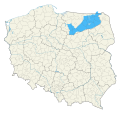
File:Mazury na mapie adm. Polski.svg
Appearance

Size of this PNG preview of this SVG file: 628 × 600 pixels. Other resolutions: 251 × 240 pixels | 503 × 480 pixels | 804 × 768 pixels | 1,072 × 1,024 pixels | 2,144 × 2,048 pixels | 5,935 × 5,669 pixels.
Original file (SVG file, nominally 5,935 × 5,669 pixels, file size: 5.48 MB)
File history
Click on a date/time to view the file as it appeared at that time.
| Date/Time | Thumbnail | Dimensions | User | Comment | |
|---|---|---|---|---|---|
| current | 18:19, 30 September 2022 |  | 5,935 × 5,669 (5.48 MB) | JakaśKreatywnaNazwa | Poprawiono południową i wschodnią granicę |
| 19:20, 27 August 2022 |  | 5,935 × 5,669 (2.38 MB) | JakaśKreatywnaNazwa | Poprawiono zachodnią granicę Mazur | |
| 19:26, 4 August 2022 |  | 5,935 × 5,669 (2.38 MB) | JakaśKreatywnaNazwa | Uploaded own work with UploadWizard |
File usage
The following page uses this file:
Global file usage
The following other wikis use this file:
- Usage on ca.wikipedia.org
- Usage on de.wikivoyage.org
- Usage on eu.wikipedia.org
- Usage on gl.wikipedia.org
- Usage on io.wikipedia.org
- Usage on it.wikipedia.org
- Usage on lv.wikipedia.org
- Usage on pl.wikipedia.org
- Usage on pl.wikivoyage.org
- Usage on pl.wiktionary.org
- Usage on ro.wikipedia.org
- Usage on ru.wikipedia.org
- Usage on uk.wikipedia.org
- Usage on www.wikidata.org
- Usage on zh.wikipedia.org

