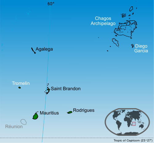
File:Mauritius (+claim islands).svg
Appearance

Size of this PNG preview of this SVG file: 500 × 463 pixels. Other resolutions: 259 × 240 pixels | 518 × 480 pixels | 829 × 768 pixels | 1,106 × 1,024 pixels | 2,212 × 2,048 pixels.
Original file (SVG file, nominally 500 × 463 pixels, file size: 1.41 MB)
File history
Click on a date/time to view the file as it appeared at that time.
| Date/Time | Thumbnail | Dimensions | User | Comment | |
|---|---|---|---|---|---|
| current | 01:24, 14 July 2014 |  | 500 × 463 (1.41 MB) | Yash400 | use accurate map of Chagos |
| 12:59, 20 January 2014 |  | 500 × 463 (1.37 MB) | Palosirkka | larger nominal size | |
| 18:50, 19 January 2014 |  | 255 × 236 (1.37 MB) | Yash400 | remove black lines | |
| 18:25, 19 January 2014 |  | 257 × 238 (1.37 MB) | Yash400 | change color | |
| 18:08, 20 November 2013 |  | 572 × 530 (1.41 MB) | Yash400 | User created page with UploadWizard |
File usage
The following 6 pages use this file:
Global file usage
The following other wikis use this file:
- Usage on af.wikipedia.org
- Usage on ann.wikipedia.org
- Usage on ar.wikipedia.org
- Usage on avk.wikipedia.org
- Usage on bh.wikipedia.org
- Usage on bn.wikipedia.org
- Usage on br.wikipedia.org
- Usage on ca.wikipedia.org
- Usage on ceb.wikipedia.org
- Usage on ckb.wikipedia.org
- Usage on de.wikipedia.org
- Usage on diq.wikipedia.org
- Usage on dty.wikipedia.org
- Usage on es.wikipedia.org
- Usage on eu.wikipedia.org
- Usage on fa.wikipedia.org
- Usage on fi.wikipedia.org
- Usage on frp.wikipedia.org
- Usage on fr.wikipedia.org
- Usage on fr.wikinews.org
- Usage on gl.wikipedia.org
- Usage on gom.wikipedia.org
- Usage on gu.wikipedia.org
- Usage on he.wikipedia.org
- Usage on ia.wikipedia.org
- Usage on id.wikipedia.org
- Usage on ilo.wikipedia.org
- Usage on incubator.wikimedia.org
- Usage on io.wikipedia.org
- Usage on ja.wikipedia.org
View more global usage of this file.
