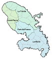
File:Martinique legende arrs.PNG
Appearance
Martinique_legende_arrs.PNG (419 × 478 pixels, file size: 16 KB, MIME type: image/png)
File history
Click on a date/time to view the file as it appeared at that time.
| Date/Time | Thumbnail | Dimensions | User | Comment | |
|---|---|---|---|---|---|
| current | 16:48, 2 January 2007 |  | 419 × 478 (16 KB) | BigonL | Carte de la Martinique avec ses 4 arrondissements. Map of French department of Martinique with its 4 "arrondissements". |
File usage
The following page uses this file:
Global file usage
The following other wikis use this file:
- Usage on cs.wikipedia.org
- Usage on cv.wikipedia.org
- Usage on el.wikipedia.org
- Usage on es.wikipedia.org
- Usage on fa.wikipedia.org
- Usage on fr.wikipedia.org
- Usage on gl.wikipedia.org
- Usage on is.wikipedia.org
- Usage on it.wikipedia.org
- Usage on ka.wikipedia.org
- Usage on lb.wikipedia.org
- Usage on mk.wikipedia.org
- Usage on oc.wikipedia.org
- Fort-de-France
- Comunas de Martinica
- Modèl:Comunas de Martinica
- L'Ajoupa-Bouillon
- Les Anses-d'Arlet
- Basse-Pointe
- Le Carbet
- Case-Pilote
- Le Diamant
- Ducos
- Fonds-Saint-Denis
- Le François
- Grand'Rivière
- Gros-Morne
- Le Lamentin
- Le Lorrain
- Macouba
- Le Marigot
- Le Marin
- Le Morne-Rouge
- Le Prêcheur
- Rivière-Pilote
- Rivière-Salée
- Le Robert
- Saint-Esprit
- Saint-Joseph (Martinica)
- Saint-Pierre (Martinica)
- Sainte-Luce (Martinica)
- Schœlcher
- La Trinité
- Les Trois-Îlets
- Le Vauclin
- Le Morne-Vert
- Bellefontaine (Martinica)
- Sainte-Marie (Martinica)
- Sainte-Anne (Martinica)
- Usage on pl.wikipedia.org
View more global usage of this file.
