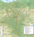
File:Mapa físico de Navarra.svg
Appearance

Size of this PNG preview of this SVG file: 548 × 600 pixels. Other resolutions: 219 × 240 pixels | 438 × 480 pixels | 702 × 768 pixels | 935 × 1,024 pixels | 1,871 × 2,048 pixels | 930 × 1,018 pixels.
Original file (SVG file, nominally 930 × 1,018 pixels, file size: 7.56 MB)
File history
Click on a date/time to view the file as it appeared at that time.
| Date/Time | Thumbnail | Dimensions | User | Comment | |
|---|---|---|---|---|---|
| current | 19:30, 2 February 2010 |  | 930 × 1,018 (7.56 MB) | Miguillen | tamaño nombres |
| 17:15, 1 February 2010 |  | 930 × 1,018 (7.52 MB) | Miguillen | mejora | |
| 00:42, 1 February 2010 |  | 930 × 1,018 (6.8 MB) | Miguillen | == {{int:filedesc}} == {{Information |Description={{es|CartMapa físico de la Comunidad Foral de Navarra}} {{en|Topographic map of the Navarre}} |Source={{fr|Extrait de [[:Image:Pyrenees topographic map-f |
File usage
The following 2 pages use this file:
Global file usage
The following other wikis use this file:
- Usage on es.wikipedia.org
- Usage on fr.wikipedia.org
- Usage on pt.wikipedia.org

