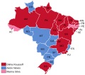
File:Mapa do Brasil - Eleição presidencial (2014) (primeiro turno).svg
Appearance

Size of this PNG preview of this SVG file: 640 × 599 pixels. Other resolutions: 256 × 240 pixels | 820 × 768 pixels | 1,094 × 1,024 pixels | 2,187 × 2,048 pixels | 4,191 × 3,924 pixels.
Original file (SVG file, nominally 4,191 × 3,924 pixels, file size: 316 KB)
File history
Click on a date/time to view the file as it appeared at that time.
| Date/Time | Thumbnail | Dimensions | User | Comment | |
|---|---|---|---|---|---|
| current | 12:53, 14 April 2022 |  | 4,191 × 3,924 (316 KB) | MatheusAlmeidadosSantos | Adequação a um novo mapa melhorado e com maior resolução. |
| 16:23, 10 April 2021 |  | 780 × 687 (396 KB) | MatheusAlmeidadosSantos | . | |
| 11:48, 21 January 2021 |  | 780 × 687 (396 KB) | Aurélio da Costa Santos 02 | . | |
| 13:34, 6 January 2021 |  | 780 × 687 (396 KB) | MatheusAlmeidadosSantos | . | |
| 15:09, 20 December 2020 |  | 780 × 687 (396 KB) | MatheusAlmeidadosSantos | AL e SE corrigidos à fonte arial. | |
| 14:06, 20 December 2020 |  | 780 × 687 (396 KB) | MatheusAlmeidadosSantos | Uploaded own work with UploadWizard |
File usage
The following page uses this file:
Global file usage
The following other wikis use this file:
- Usage on pt.wikipedia.org

