
File:Mapa de la frontera marítima Chile-Perú.svg

Size of this PNG preview of this SVG file: 785 × 600 pixels. Other resolutions: 314 × 240 pixels | 628 × 480 pixels | 1,005 × 768 pixels | 1,280 × 978 pixels | 2,560 × 1,956 pixels | 894 × 683 pixels.
Original file (SVG file, nominally 894 × 683 pixels, file size: 165 KB)
| This is a file from the Wikimedia Commons. Information from its description page there is shown below. Commons is a freely licensed media file repository. You can help. |
Summary
| Description |
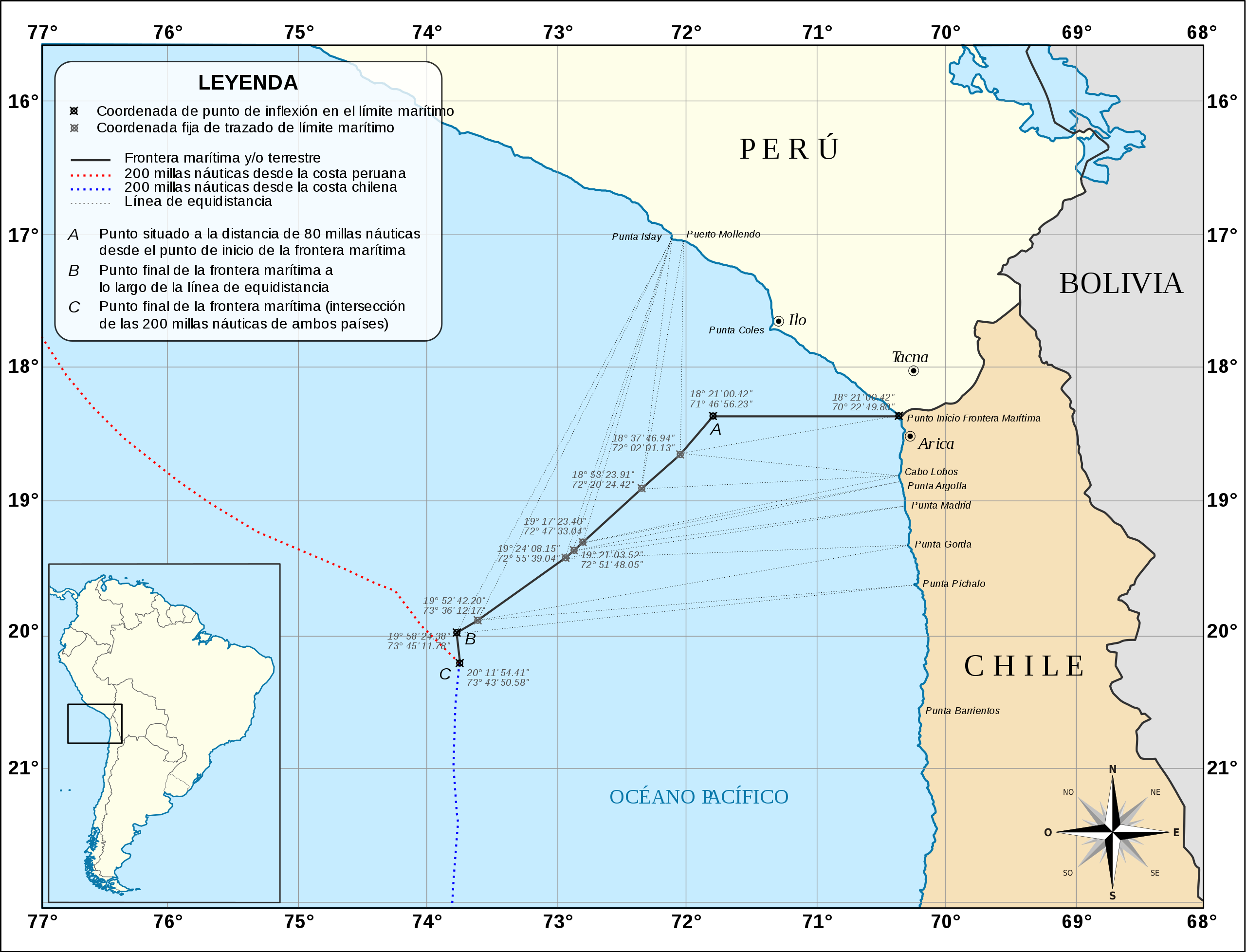
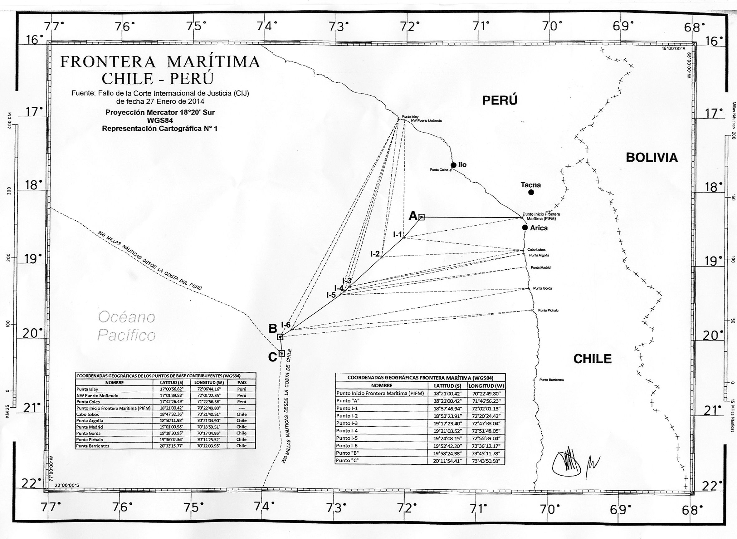
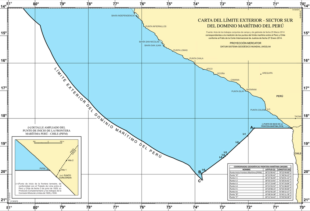
Español: Mapa mostrando el límite marítimo acordado entre los gobiernos de Chile y Perú luego de la sentencia del 27 de enero de 2014 de la Corte Internacional de Justicia sobre la disputa de la frontera marítima entre ambos países. |
| Date | |
| Source |
Own work |
| Author | Shadowxfox |
Licensing
I, the copyright holder of this work, hereby publish it under the following license:
This file is licensed under the Creative Commons Attribution-Share Alike 3.0 Unported license.
- You are free:
- to share – to copy, distribute and transmit the work
- to remix – to adapt the work
- Under the following conditions:
- attribution – You must give appropriate credit, provide a link to the license, and indicate if changes were made. You may do so in any reasonable manner, but not in any way that suggests the licensor endorses you or your use.
- share alike – If you remix, transform, or build upon the material, you must distribute your contributions under the same or compatible license as the original.
File history
Click on a date/time to view the file as it appeared at that time.
| Date/Time | Thumbnail | Dimensions | User | Comment | |
|---|---|---|---|---|---|
| current | 15:49, 4 April 2014 | | 894 × 683 (165 KB) | Milenioscuro | corrijo leyenda a petición en mi discusión |
| 10:03, 4 April 2014 |  | 894 × 683 (165 KB) | Milenioscuro | leyenda | |
| 10:01, 4 April 2014 |  | 894 × 683 (164 KB) | Milenioscuro | corrijo y añado leyenda mas clara | |
| 02:00, 4 April 2014 |  | 894 × 683 (158 KB) | Milenioscuro | User created page with UploadWizard |
File usage
The following page uses this file:
Global file usage
The following other wikis use this file:
- Usage on ca.wikipedia.org
- Usage on es.wikipedia.org
- Usage on fr.wikipedia.org
- Usage on he.wikipedia.org
- Usage on it.wikipedia.org
- Usage on mk.wikipedia.org
- Usage on pl.wikipedia.org
- Usage on pt.wikipedia.org
- Usage on www.wikidata.org