
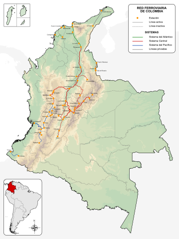
File:Mapa de Colombia (ferrocarriles).svg

Size of this PNG preview of this SVG file: 449 × 600 pixels. Other resolutions: 180 × 240 pixels | 359 × 480 pixels | 575 × 768 pixels | 767 × 1,024 pixels | 1,534 × 2,048 pixels | 1,420 × 1,896 pixels.
Original file (SVG file, nominally 1,420 × 1,896 pixels, file size: 1.1 MB)
| This is a file from the Wikimedia Commons. Information from its description page there is shown below. Commons is a freely licensed media file repository. You can help. |
.svg)
Summary
| Description |
English: Railroads of Colombia
Español: Red ferroviaria de Colombia |
| Date | |
| Source |
Own work
|
| Author | Milenioscuro |
Licensing
I, the copyright holder of this work, hereby publish it under the following license:
This file is licensed under the Creative Commons Attribution-Share Alike 3.0 Unported license.
- You are free:
- to share – to copy, distribute and transmit the work
- to remix – to adapt the work
- Under the following conditions:
- attribution – You must give appropriate credit, provide a link to the license, and indicate if changes were made. You may do so in any reasonable manner, but not in any way that suggests the licensor endorses you or your use.
- share alike – If you remix, transform, or build upon the material, you must distribute your contributions under the same or compatible license as the original.
File history
Click on a date/time to view the file as it appeared at that time.
| Date/Time | Thumbnail | Dimensions | User | Comment | |
|---|---|---|---|---|---|
| current | 02:32, 9 February 2022 | | 1,420 × 1,896 (1.1 MB) | Milenioscuro | arreglos a algunas lineas |
| 21:25, 7 February 2022 |  | 1,420 × 1,896 (1.08 MB) | Milenioscuro | arreglos, relieve, separación de los sistemas | |
| 03:40, 20 December 2021 |  | 1,420 × 1,896 (371 KB) | Milenioscuro | nuevo esquema | |
| 12:57, 8 September 2014 |  | 1,422 × 1,898 (518 KB) | Milenioscuro | correccions de colores y limites departamentales | |
| 05:39, 24 May 2012 |  | 1,450 × 1,893 (662 KB) | Milenioscuro | updated | |
| 06:45, 14 October 2011 |  | 1,301 × 1,708 (637 KB) | Milenioscuro | estaciones mas visibles | |
| 01:42, 4 January 2010 |  | 1,301 × 1,708 (637 KB) | Milenioscuro | arreglos | |
| 18:58, 2 January 2010 |  | 1,301 × 1,708 (637 KB) | Milenioscuro | {{Information |Description={{en|1=Railroads of Colombia}} {{es|1=Red ferroviaria de Colombia}} |Source={{own}} |Author=Shadowxfox |Date=2010-01-01 |Permission= |other_versions= }} Category:SVG maps of Colombia [[Category:Road maps |
File usage
The following 4 pages use this file:
Global file usage
The following other wikis use this file:
- Usage on atj.wikipedia.org
- Usage on de.wikipedia.org
- Usage on es.wikipedia.org
- Usage on fr.wikipedia.org
- Usage on hu.wikipedia.org
- Usage on ja.wikipedia.org
- Usage on no.wikipedia.org
.svg)