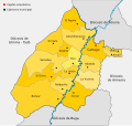
File:Mapa Diocesis de Cartago.svg
Appearance

Size of this PNG preview of this SVG file: 637 × 599 pixels. Other resolutions: 255 × 240 pixels | 510 × 480 pixels | 816 × 768 pixels | 1,089 × 1,024 pixels | 2,177 × 2,048 pixels | 860 × 809 pixels.
Original file (SVG file, nominally 860 × 809 pixels, file size: 367 KB)
File history
Click on a date/time to view the file as it appeared at that time.
| Date/Time | Thumbnail | Dimensions | User | Comment | |
|---|---|---|---|---|---|
| current | 23:32, 26 May 2012 |  | 860 × 809 (367 KB) | SajoR | correcciones en los limites y agrego centros poblados con parroquia |
| 08:16, 12 September 2011 |  | 944 × 890 (217 KB) | SajoR | mejoras visuales | |
| 04:29, 12 September 2011 |  | 944 × 890 (242 KB) | SajoR | {{Information |Description ={{es|1=Mapa de la Diócesis de Cartago. colombia}} |Source ={{own}} |Author =SajoR |Date =2011-09-11 |Permission ='''Trabajo propio, reconocimiento requerido, mantener licencia:(C |
File usage
The following page uses this file:
Global file usage
The following other wikis use this file:
- Usage on de.wikipedia.org
- Usage on es.wikipedia.org
- Usage on fr.wikipedia.org
- Usage on id.wikipedia.org
- Usage on it.wikipedia.org
- Usage on jv.wikipedia.org
- Usage on nl.wikipedia.org
- Usage on pl.wikipedia.org
