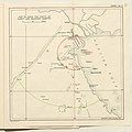
File:Map to show the Limits of Kuwait and Adjacent Country (1913).jpg
Appearance

Size of this preview: 614 × 599 pixels. Other resolutions: 246 × 240 pixels | 492 × 480 pixels | 787 × 768 pixels | 1,050 × 1,024 pixels | 2,099 × 2,048 pixels | 3,457 × 3,373 pixels.
Original file (3,457 × 3,373 pixels, file size: 1.13 MB, MIME type: image/jpeg)
File history
Click on a date/time to view the file as it appeared at that time.
| Date/Time | Thumbnail | Dimensions | User | Comment | |
|---|---|---|---|---|---|
| current | 12:37, 26 July 2018 |  | 3,457 × 3,373 (1.13 MB) | Ratzer | Cropped 4 % horizontally, 6 % vertically using CropTool with precise mode. |
| 10:02, 26 July 2018 |  | 3,611 × 3,600 (1.31 MB) | Ratzer | User created page with UploadWizard |
File usage
The following 4 pages use this file:
Global file usage
The following other wikis use this file:
- Usage on ar.wikipedia.org
- Usage on bs.wikipedia.org
- Usage on fa.wikipedia.org
- Usage on he.wikipedia.org
- Usage on hr.wikipedia.org
- Usage on id.wikipedia.org
- Usage on it.wikipedia.org
- Usage on ja.wikipedia.org
- Usage on nl.wikipedia.org
- Usage on ru.wikipedia.org
- Usage on uk.wikipedia.org
- Usage on www.wikidata.org

