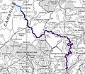
File:Map of the River Wye (West Midlands and Wales, UK).jpeg
Appearance

Size of this preview: 687 × 600 pixels. Other resolutions: 275 × 240 pixels | 550 × 480 pixels | 771 × 673 pixels.
Original file (771 × 673 pixels, file size: 127 KB, MIME type: image/jpeg)
File history
Click on a date/time to view the file as it appeared at that time.
| Date/Time | Thumbnail | Dimensions | User | Comment | |
|---|---|---|---|---|---|
| current | 23:49, 15 August 2012 |  | 771 × 673 (127 KB) | RobinLovelace~commonswiki |
File usage
The following 3 pages use this file:
Global file usage
The following other wikis use this file:
- Usage on fi.wikipedia.org
- Usage on fy.wikipedia.org
- Usage on he.wikipedia.org
- Usage on ja.wikipedia.org
- Usage on nl.wikipedia.org
- Usage on no.wikipedia.org
- Usage on sl.wikipedia.org
- Usage on sv.wikipedia.org
- Usage on xmf.wikipedia.org
