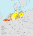
File:Map of the Low German Dialects.svg
Appearance

Size of this PNG preview of this SVG file: 646 × 600 pixels. Other resolutions: 258 × 240 pixels | 517 × 480 pixels | 827 × 768 pixels | 1,103 × 1,024 pixels | 2,206 × 2,048 pixels | 700 × 650 pixels.
Original file (SVG file, nominally 700 × 650 pixels, file size: 246 KB)
File history
Click on a date/time to view the file as it appeared at that time.
| Date/Time | Thumbnail | Dimensions | User | Comment | |
|---|---|---|---|---|---|
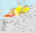
| current | 18:54, 11 December 2017 |  | 700 × 650 (246 KB) | Alphathon | Border in Lake Geneva and the Rhine delta |
| 18:24, 11 December 2017 |  | 700 × 650 (245 KB) | Alphathon | Corrected some settlement placements and Anglicised names | |
| 17:04, 11 December 2017 |  | 700 × 650 (245 KB) | Alphathon | Correction (Holland → the Netherlands) | |
| 21:54, 27 October 2015 |  | 700 × 650 (266 KB) | Alphathon | Corrected some minor errors and cropped | |
| 14:30, 7 February 2011 |  | 789 × 852 (292 KB) | Alphathon | Missed some in previous edit | |
| 14:29, 7 February 2011 |  | 789 × 852 (292 KB) | Alphathon | Minor font change (so it renders properly in previews etc.) | |
| 14:14, 7 February 2011 |  | 789 × 852 (290 KB) | Alphathon | Translated into English since it has an English title. German Version will be re-uploaded under a different name | |
| 01:15, 7 February 2011 |  | 789 × 852 (285 KB) | Alphathon | {{Information |Description={{de|Darstellungskarte der niederdeutschen Mundarten seit 1945}} {{en|Distribution map of the Low Saxon and Low Franconian languages since 1945}} |Source=*File:Verbreitungsgebiet_der_heutigen_niederdeutschen_Mundarten.PNG |
File usage
The following 4 pages use this file:
Global file usage
The following other wikis use this file:
- Usage on an.wikipedia.org
- Usage on ar.wikipedia.org
- Usage on en.wikivoyage.org
- Usage on nds-nl.wikipedia.org
- Usage on nl.wikipedia.org
- Usage on ru.wikipedia.org
- Usage on simple.wikipedia.org
- Usage on zh.wikivoyage.org


