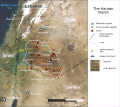
File:Map of the Hauran (satellite version).svg
Appearance

Size of this PNG preview of this SVG file: 647 × 581 pixels. Other resolutions: 267 × 240 pixels | 535 × 480 pixels | 855 × 768 pixels | 1,140 × 1,024 pixels | 2,281 × 2,048 pixels.
Original file (SVG file, nominally 647 × 581 pixels, file size: 2.84 MB)
File history
Click on a date/time to view the file as it appeared at that time.
| Date/Time | Thumbnail | Dimensions | User | Comment | |
|---|---|---|---|---|---|
| current | 12:34, 22 February 2024 |  | 647 × 581 (2.84 MB) | Arrow303 | w/o border |
| 12:32, 22 February 2024 |  | 648 × 581 (2.84 MB) | Arrow303 | some technical fixes | |
| 17:25, 12 September 2019 |  | 649 × 579 (4.56 MB) | Amitchell125 | minor corrections | |
| 07:57, 12 September 2019 |  | 649 × 579 (4.56 MB) | Amitchell125 | Improved accuracy and readability | |
| 22:57, 9 September 2019 |  | 649 × 579 (4.57 MB) | Amitchell125 | correction | |
| 22:42, 9 September 2019 |  | 649 × 579 (4.57 MB) | Amitchell125 | User created page with UploadWizard |
File usage
The following 3 pages use this file:
Global file usage
The following other wikis use this file:
- Usage on id.wikipedia.org
- Usage on it.wikipedia.org
- Usage on ro.wikipedia.org
- Usage on ru.wikipedia.org
- Usage on uk.wikipedia.org


