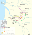
File:Map of route of Lancaster's chevauchée of 1346.svg
Appearance

Size of this PNG preview of this SVG file: 393 × 599 pixels. Other resolutions: 157 × 240 pixels | 315 × 480 pixels | 504 × 768 pixels | 672 × 1,024 pixels | 1,343 × 2,048 pixels | 698 × 1,064 pixels.
Original file (SVG file, nominally 698 × 1,064 pixels, file size: 303 KB)
File history
Click on a date/time to view the file as it appeared at that time.
| Date/Time | Thumbnail | Dimensions | User | Comment | |
|---|---|---|---|---|---|
| current | 18:41, 9 November 2021 |  | 698 × 1,064 (303 KB) | Goran tek-en | Changed color to work better for people with color deficiency |
| 18:30, 9 November 2021 |  | 698 × 1,064 (303 KB) | Goran tek-en | Changed view box, font size and some more | |
| 15:59, 22 November 2018 |  | 698 × 1,064 (205 KB) | Goran tek-en | {{Information |description ={{en|1=Map of the route of Lancaster's chevauchée of 1346, part of the Hundred Years' War. This map shows the Lancaster's movements during the campaign and the most important sieges and sackings of towns.}} |date =20181122 |source ={{Own}}<br> Derived from; * [https://www.openstreetmap.org/#map=8/45.141/0.549 OSM] Information from: * [https://web.archive.org/web/20170425121316/https://erenow.com/postclassical/trialbybattle/16.html Web archiv... |
File usage
The following 4 pages use this file:
Global file usage
The following other wikis use this file:
- Usage on fr.wikipedia.org
- Usage on hr.wikipedia.org
- Usage on hu.wikipedia.org
- Usage on sh.wikipedia.org


