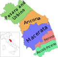
File:Map of region of Marche, Italy, with provinces-en.svg
Appearance

Size of this PNG preview of this SVG file: 609 × 600 pixels. Other resolutions: 244 × 240 pixels | 488 × 480 pixels | 780 × 768 pixels | 1,040 × 1,024 pixels | 2,080 × 2,048 pixels | 3,504 × 3,450 pixels.
Original file (SVG file, nominally 3,504 × 3,450 pixels, file size: 114 KB)
File history
Click on a date/time to view the file as it appeared at that time.
| Date/Time | Thumbnail | Dimensions | User | Comment | |
|---|---|---|---|---|---|
| current | 23:48, 6 October 2022 |  | 3,504 × 3,450 (114 KB) | Krepideia | Borders update: detachment of Municipalities of Montecopiolo and Sassofeltrio from region Marche (2021) |
| 00:04, 4 December 2010 |  | 3,504 × 3,450 (115 KB) | Vonvikken | == {{int:filedesc}} == {{Information |Description={{DescrMapRegionItaly|MAR|English}} |Source={{own}} |Author=Vonvikken |Date=2010-12-04 |Permission= |other_versions=100px|Blank[[File:Map_of_r |
File usage
The following 14 pages use this file:
Global file usage
The following other wikis use this file:
- Usage on en.wikivoyage.org
- Usage on incubator.wikimedia.org
- Usage on ru.wikivoyage.org
- Usage on sco.wikipedia.org
- Usage on zh.wikipedia.org


