File:Map of invasion of Yugoslavia - Situation map.svg
Appearance

Size of this PNG preview of this SVG file: 686 × 599 pixels. Other resolutions: 275 × 240 pixels | 549 × 480 pixels | 879 × 768 pixels | 1,172 × 1,024 pixels | 2,344 × 2,048 pixels | 1,300 × 1,136 pixels.
Original file (SVG file, nominally 1,300 × 1,136 pixels, file size: 4.52 MB)
File history
Click on a date/time to view the file as it appeared at that time.
| Date/Time | Thumbnail | Dimensions | User | Comment | |
|---|---|---|---|---|---|
| current | 16:46, 4 May 2020 |  | 1,300 × 1,136 (4.52 MB) | Goran tek-en | Trying to fix text rendering problems |
| 16:53, 3 May 2020 |  | 1,300 × 1,136 (4.53 MB) | Goran tek-en | Minor symbol edit | |
| 15:01, 3 May 2020 |  | 1,300 × 1,136 (4.53 MB) | Goran tek-en | Hopefully correct now | |
| 14:39, 3 May 2020 |  | 1,300 × 1,136 (4.52 MB) | Goran tek-en | Preview problems, test version | |
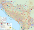
| 14:26, 3 May 2020 |  | 1,300 × 1,136 (4.53 MB) | Goran tek-en | {{Information |description ={{en|1=The map shows the initial positions of the Axis forces and the Yugoslav Royal Army.}} |date =20200503 |source ={{Own}}<br> {{Derived from|Yugoslavia (1939–41) location map.svg|Flag of Germany (1935–1945).svg|Flag of Italy (1861-1946) crowned.svg|Flag of Hungary (1915-1918, 1919-1946).svg|APP-6 Mountain Infantry.svg|NATO_Map_Symbol_-_Motorised_Infantry.svg|Flag of Yugoslavia (1918–1941).svg|State Flag of Greece (1863-1924 and 1935-1973... |
File usage
The following page uses this file:
Global file usage
The following other wikis use this file:
- Usage on hr.wikipedia.org


