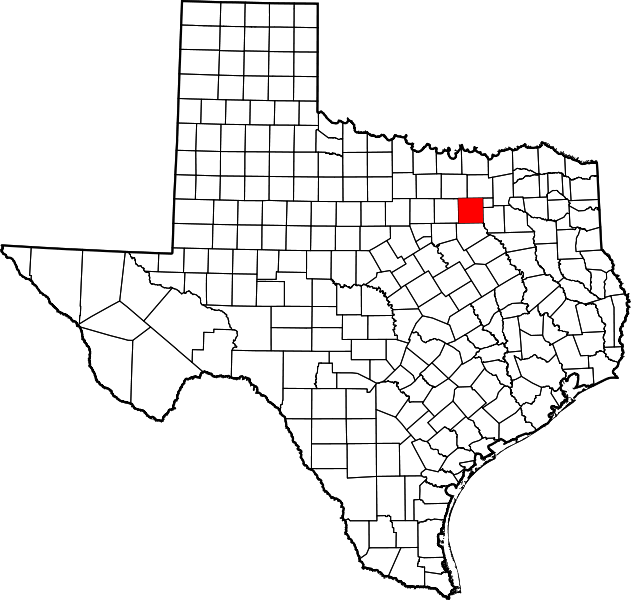
File:Map of Texas highlighting Dallas County.svg
Appearance

Size of this PNG preview of this SVG file: 631 × 600 pixels. Other resolutions: 253 × 240 pixels | 505 × 480 pixels | 808 × 768 pixels | 1,078 × 1,024 pixels | 2,155 × 2,048 pixels | 1,386 × 1,317 pixels.
Original file (SVG file, nominally 1,386 × 1,317 pixels, file size: 222 KB)
File history
Click on a date/time to view the file as it appeared at that time.
| Date/Time | Thumbnail | Dimensions | User | Comment | |
|---|---|---|---|---|---|
| current | 00:42, 5 July 2024 |  | 1,386 × 1,317 (222 KB) | Nux | fix rendering (remove clipping), uniform colors |
| 16:48, 12 February 2006 |  | 12,473 × 11,855 (304 KB) | David Benbennick | {{subst:User:Dbenbenn/clm|county=Dallas County|state=Texas|type=county}} |
File usage
The following 63 pages use this file:
- Addison, Texas
- Alpha, Texas
- Balch Springs, Texas
- Bear Creek Ranch, Texas
- Buckingham, Richardson, Texas
- Carrollton, Texas
- Cedar Hill, Texas
- Cockrell Hill, Texas
- Combine, Texas
- Coppell, Texas
- Dallas
- Dallas County, Texas
- DeSoto, Texas
- Duck Creek, Garland, Texas
- Duncanville, Texas
- East Dallas
- Embree, Garland, Texas
- Farmers Branch, Texas
- Ferris, Texas
- Fruitdale, Dallas
- Garland, Texas
- Glenn Heights, Texas
- Grand Prairie, Texas
- Grapevine, Texas
- Hattersville, Sunnyvale, Texas
- Highland Park, Texas
- Hord's Ridge, Texas
- Hutchins, Texas
- Irving, Texas
- Kleberg, Dallas
- La Réunion (Dallas)
- Lancaster, Texas
- Liberty Grove, Dallas County, Texas
- List of census-designated places in Texas
- List of counties in Texas
- Long Creek, Sunnyvale, Texas
- Mesquite, Texas
- National Register of Historic Places listings in Dallas County, Texas
- New Hope, Sunnyvale, Texas
- Oak Cliff
- Ovilla, Texas
- Preston Hollow, Dallas
- Renner, Dallas
- Richardson, Texas
- Rowlett, Texas
- Rylie, Dallas
- Sachse, Texas
- Sand Branch, Dallas County, Texas
- Scyene, Dallas
- Seagoville, Texas
- Sunnyvale, Texas
- Trinity Mills, Texas
- Tripp, Sunnyvale, Texas
- University Park, Texas
- Wilmer, Texas
- Wylie, Texas
- Talk:Eagle Ford Formation
- User:Nyttend/County templates/TX/1
- User:Patapsco913/sandbox
- File talk:Map of Texas highlighting Dallas County.svg
- Template:Dallas County, Texas
- Category:Populated places in Dallas County, Texas
- Category:Wikipedia requested photographs in Dallas County, Texas
Global file usage
The following other wikis use this file:
- Usage on af.wikipedia.org
- Usage on ar.wikipedia.org
- دالاس
- مقاطعة دالاس (تكساس)
- غراند براري (تكساس)
- إيرفينغ (تكساس)
- بالش سبرينغز
- أديسون (تكساس)
- دانكنفيل (تكساس)
- يونيفرسيتي بارك (تكساس)
- روليت (تكساس)
- ريتشاردسون (تكساس)
- سنيفيل (تكساس)
- مسكيت (تكساس)
- هايلاند بارك (تكساس)
- كارولتون (تكساس)
- سيدار هيل
- كوكريل هيل
- كومبين
- كوبيل (تكساس)
- دي سوتو (تكساس)
- فارمرز برانش
- فيريس (تكساس)
- غارلاند
- غلين هايتس
- غرابفين
- هاتشينز
- لانكستر (تكساس)
- لويسفيل (تكساس)
- أوفيلا
- ساتشس
- سيغوفيل
- ويلمر
- ويلي (تكساس)
- قالب:مقاطعة دالاس (تكساس)
- Usage on azb.wikipedia.org
- Usage on az.wikipedia.org
- Usage on be.wikipedia.org
- Usage on bg.wikipedia.org
- Usage on bpy.wikipedia.org
- Usage on ca.wikipedia.org
- Usage on cdo.wikipedia.org
- Usage on ceb.wikipedia.org
- Usage on cs.wikipedia.org
- Usage on cy.wikipedia.org
- Usage on de.wikipedia.org
View more global usage of this file.
