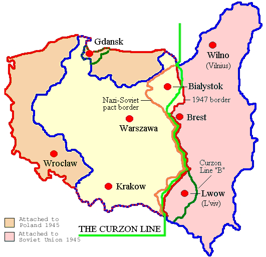
File:Map of Poland (1945) corr.png
Appearance
Map_of_Poland_(1945)_corr.png (531 × 513 pixels, file size: 80 KB, MIME type: image/png)
File history
Click on a date/time to view the file as it appeared at that time.
| Date/Time | Thumbnail | Dimensions | User | Comment | |
|---|---|---|---|---|---|
| current | 16:21, 25 February 2017 |  | 531 × 513 (80 KB) | Hohum | Removed border, cropped |
| 12:17, 22 May 2016 |  | 617 × 513 (81 KB) | Hohum | Reworked colours for clarity | |
| 16:40, 11 May 2012 |  | 617 × 513 (90 KB) | Hohum | Cleanup | |
| 17:18, 28 March 2006 |  | 617 × 513 (108 KB) | Wkentaur | Map of Poland 1945 modified from [:Image:Map of Poland (1945).png] to correct terminology *Author: en:User: Adam Carr *Source: en:Image:Map of Poland (1945) corr.jpg Category:Historical maps of Poland |
File usage
The following 5 pages use this file:
Global file usage
The following other wikis use this file:
- Usage on ar.wikipedia.org
- Usage on be-tarask.wikipedia.org
- Usage on ca.wikipedia.org
- Usage on da.wikipedia.org
- Usage on et.wikipedia.org
- Usage on hr.wikipedia.org
- Usage on hy.wikipedia.org
- Usage on id.wikipedia.org
- Usage on it.wikipedia.org
- Usage on mk.wikipedia.org
- Usage on nl.wikipedia.org
- Usage on no.wikipedia.org
- Usage on pnb.wikipedia.org
- Usage on ro.wikipedia.org
- Usage on sr.wikipedia.org
- Usage on sv.wikipedia.org
- Usage on ur.wikipedia.org


