
File:Map of Operation Eagle Pull evacuation sites.jpg
No higher resolution available.
Map_of_Operation_Eagle_Pull_evacuation_sites.jpg (600 × 552 pixels, file size: 95 KB, MIME type: image/jpeg)
| This is a file from the Wikimedia Commons. Information from its description page there is shown below. Commons is a freely licensed media file repository. You can help. |
Summary
| Description |
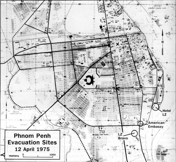
English: Map of possible helicopter landing zones for use in Operation Eagle Pull |
| Date | |
| Source | http://www.history.navy.mil/index.html |
| Author | US Navy |
Licensing
This file is a work of a sailor or employee of the U.S. Navy, taken or made as part of that person's official duties. As a work of the U.S. federal government, it is in the public domain in the United States.
|
 | |
| This file has been identified as being free of known restrictions under copyright law, including all related and neighboring rights. | ||
File history
Click on a date/time to view the file as it appeared at that time.
| Date/Time | Thumbnail | Dimensions | User | Comment | |
|---|---|---|---|---|---|
| current | 09:11, 7 February 2010 | | 600 × 552 (95 KB) | Mztourist | {{Information |Description={{en|1=Map of possible helicopter landing zones for use in Operation Eagle Pull}} |Source=http://www.history.navy.mil/index.html |Author=US Navy |Date=1975-04 |Permission= |other_versions= }} Category:Operation Eagle Pull [ |
File usage
The following 2 pages use this file:
Global file usage
The following other wikis use this file:
- Usage on br.wikipedia.org
- Usage on de.wikipedia.org
- Usage on ru.wikipedia.org
- Usage on vi.wikipedia.org
- Usage on zh.wikipedia.org