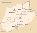
File:Map of Montefeltro.svg
Appearance

Size of this PNG preview of this SVG file: 663 × 600 pixels. Other resolutions: 265 × 240 pixels | 531 × 480 pixels | 849 × 768 pixels | 1,132 × 1,024 pixels | 2,264 × 2,048 pixels | 1,680 × 1,520 pixels.
Original file (SVG file, nominally 1,680 × 1,520 pixels, file size: 97 KB)
File history
Click on a date/time to view the file as it appeared at that time.
| Date/Time | Thumbnail | Dimensions | User | Comment | |
|---|---|---|---|---|---|
| current | 22:17, 29 June 2021 |  | 1,680 × 1,520 (97 KB) | Krepideia | municipality writing fix |
| 21:02, 29 June 2021 |  | 1,680 × 1,520 (97 KB) | Krepideia | borders fix | |
| 20:17, 29 June 2021 |  | 1,680 × 1,520 (97 KB) | Krepideia | Aggregation of Montecopiolo and Sassofeltrio to region Emilia Romagna (2021) | |
| 17:58, 16 October 2009 |  | 1,680 × 1,520 (99 KB) | Actormusicus | {{Information |Description={{en|1=Map of historical region of Montefeltro (Italy)}} {{it|1=Mappa della regione storica del Montefeltro}} |Source={{en|Derivative work from [http://www.openstreetmap.org/ OpenStreetMap], released with CC-BY-SA-2.0 license}} |
File usage
The following page uses this file:
Global file usage
The following other wikis use this file:
- Usage on bg.wikipedia.org
- Usage on br.wikipedia.org
- Usage on cs.wikipedia.org
- Usage on de.wikipedia.org
- Usage on fr.wikipedia.org
- Usage on it.wikipedia.org
- Usage on ka.wikipedia.org
- Usage on la.wikipedia.org
- Usage on pt.wikipedia.org
- Usage on sh.wikipedia.org
- Usage on uk.wikipedia.org
- Usage on zh.wikipedia.org

