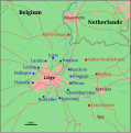
File:Map of Liege defences.svg
Appearance

Size of this PNG preview of this SVG file: 593 × 600 pixels. Other resolutions: 237 × 240 pixels | 475 × 480 pixels | 760 × 768 pixels | 1,013 × 1,024 pixels | 2,026 × 2,048 pixels | 721 × 729 pixels.
Original file (SVG file, nominally 721 × 729 pixels, file size: 55 KB)
File history
Click on a date/time to view the file as it appeared at that time.
| Date/Time | Thumbnail | Dimensions | User | Comment | |
|---|---|---|---|---|---|
| current | 09:08, 20 March 2023 |  | 721 × 729 (55 KB) | The RedBurn | typo (accent), -unneeded translations |
| 09:03, 20 March 2023 |  | 721 × 729 (59 KB) | The RedBurn | +scale (very approximate) based on PNG file | |
| 08:51, 20 March 2023 |  | 721 × 729 (53 KB) | The RedBurn | typo (missing accents) | |
| 08:48, 20 March 2023 |  | 721 × 729 (53 KB) | The RedBurn | File uploaded using svgtranslate tool (https://svgtranslate.toolforge.org/). Added translation for de. | |
| 08:27, 20 March 2023 |  | 721 × 729 (53 KB) | The RedBurn | typo Hollogne | |
| 08:26, 20 March 2023 |  | 721 × 729 (53 KB) | The RedBurn | File uploaded using svgtranslate tool (https://svgtranslate.toolforge.org/). Added translation for fr. | |
| 08:02, 20 March 2023 |  | 721 × 729 (55 KB) | The RedBurn | New try with Inkscape SVG format | |
| 14:14, 5 February 2012 |  | 721 × 729 (48 KB) | Grandiose | optimise, fix | |
| 14:08, 5 February 2012 |  | 721 × 729 (99 KB) | Grandiose | == {{int:filedesc}} == {{Information |Description=SVG Map of fortresses around Liege in Belgium, map source: [http://www.demis.nl/mapserver/mapper.asp] |Source={{Derived from|Festungsring_Luettich_Karte.png|display=50}} |Date=2012-02-05 14:07 (UTC) |Autho |
File usage
The following 7 pages use this file:
Global file usage
The following other wikis use this file:
- Usage on ar.wikipedia.org
- Usage on arz.wikipedia.org
- Usage on ca.wikipedia.org
- Usage on da.wikipedia.org
- Usage on de.wikipedia.org
- Usage on es.wikipedia.org
- Usage on fr.wikipedia.org
- Usage on nl.wikipedia.org
- Usage on sv.wikipedia.org
- Usage on www.wikidata.org

