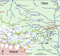
File:Map of Kharta region, east of Mount Everest.svg
Appearance

Size of this PNG preview of this SVG file: 642 × 599 pixels. Other resolutions: 257 × 240 pixels | 514 × 480 pixels | 823 × 768 pixels | 1,097 × 1,024 pixels | 2,194 × 2,048 pixels | 1,279 × 1,194 pixels.
Original file (SVG file, nominally 1,279 × 1,194 pixels, file size: 464 KB)
File history
Click on a date/time to view the file as it appeared at that time.
| Date/Time | Thumbnail | Dimensions | User | Comment | |
|---|---|---|---|---|---|
| current | 19:31, 26 August 2014 |  | 1,279 × 1,194 (464 KB) | Thincat | 1921 Everest reconnaissance routes and example trekking route shown |
| 23:11, 25 August 2014 |  | 1,279 × 1,194 (451 KB) | Thincat | Minor additions and corrections | |
| 16:19, 25 August 2014 |  | 1,279 × 1,194 (422 KB) | Thincat | Lumeh, Kangchungtse (Makalu II), ... | |
| 10:18, 25 August 2014 |  | 1,279 × 1,194 (420 KB) | Thincat | Extended north | |
| 23:51, 24 August 2014 |  | 1,280 × 718 (105 KB) | Thincat | Les violent colours | |
| 23:30, 24 August 2014 |  | 1,280 × 718 (105 KB) | Thincat | Add Rongbuk Glacier, etc. | |
| 22:45, 24 August 2014 |  | 1,280 × 718 (102 KB) | Thincat | More tidying | |
| 20:08, 24 August 2014 |  | 1,213 × 713 (93 KB) | Thincat | Slight tidy | |
| 19:30, 24 August 2014 |  | 1,213 × 713 (89 KB) | Thincat | Crop | |
| 19:25, 24 August 2014 |  | 1,231 × 844 (87 KB) | Thincat | Various. Continuing Kharta Chu, etc |
File usage
The following 3 pages use this file:
Global file usage
The following other wikis use this file:
- Usage on de.wikipedia.org
- Usage on hi.wikipedia.org
- Usage on it.wikipedia.org
- Usage on pa.wikipedia.org
- Usage on zh.wikipedia.org
