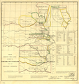
File:Map of Indian territory 1836.png
Appearance

Size of this preview: 491 × 600 pixels. Other resolutions: 196 × 240 pixels | 393 × 480 pixels | 628 × 768 pixels | 838 × 1,024 pixels | 1,676 × 2,048 pixels | 7,477 × 9,136 pixels.
Original file (7,477 × 9,136 pixels, file size: 92.32 MB, MIME type: image/png)
File history
Click on a date/time to view the file as it appeared at that time.
| Date/Time | Thumbnail | Dimensions | User | Comment | |
|---|---|---|---|---|---|
| current | 15:31, 5 March 2018 |  | 7,477 × 9,136 (92.32 MB) | Ww2censor | Higher resolution from source converted from jpg to png |
| 21:37, 6 April 2008 |  | 698 × 744 (655 KB) | File Upload Bot (Magnus Manske) | {{BotMoveToCommons|en.wikipedia}} {{Information |Description={{en|Map of Indian territory - 1836 '''Source:''' Image is from the [http://memory.loc.gov/ammem/gmdhtml/gmdhome.html Library of Congress] and is in the public domain.<br> '''Area:''' 698x744 |
File usage
The following 3 pages use this file:
Global file usage
The following other wikis use this file:
- Usage on bg.wikipedia.org
- Usage on ca.wikipedia.org
- Usage on de.wikipedia.org
- Usage on eo.wikipedia.org
- Usage on fr.wikipedia.org
- Usage on he.wikipedia.org
- Usage on it.wikipedia.org
- Usage on ja.wikipedia.org
- Usage on kk.wikipedia.org
- Usage on ko.wikipedia.org
- Usage on mk.wikipedia.org
- Usage on pl.wikipedia.org
- Usage on pt.wikipedia.org
- Usage on ru.wikipedia.org
- Usage on sr.wikipedia.org
- Usage on uk.wikipedia.org

