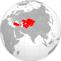
File:Map of Independent Turkic countries.svg
Appearance

Size of this PNG preview of this SVG file: 550 × 550 pixels. Other resolutions: 240 × 240 pixels | 480 × 480 pixels | 768 × 768 pixels | 1,024 × 1,024 pixels | 2,048 × 2,048 pixels.
Original file (SVG file, nominally 550 × 550 pixels, file size: 571 KB)
File history
Click on a date/time to view the file as it appeared at that time.
| Date/Time | Thumbnail | Dimensions | User | Comment | |
|---|---|---|---|---|---|
| current | 22:03, 4 August 2020 |  | 550 × 550 (571 KB) | Hogweard | {{Information |description={{en|Map of independent Turkic countries}} |date=2020-08-04 |source={{f|Eurasia orthographic selectable.svg}} |author={{u|Hogweard}} |permission={{self|cc-by-sa-3.0|GFDL}} |other versions={{f|Map of independent Turkic countries..png}} }} Category:Turkic states Category:Maps of Turkey Category:Political maps of Azerbaijan Category:Location maps of Turkmenistan Category:Maps of Uzbekistan Category:Maps of Kazakhstan Category:Maps of Kyrgyzstan |
File usage
The following 2 pages use this file:
Global file usage
The following other wikis use this file:
- Usage on fa.wikipedia.org
- Usage on ka.wikipedia.org
- Usage on mg.wikipedia.org
- Usage on pt.wikipedia.org
- Usage on simple.wikipedia.org
- Usage on sw.wikipedia.org

