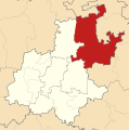
File:Map of Gauteng with Metsweding highlighted (2009).svg
Appearance

Size of this PNG preview of this SVG file: 595 × 600 pixels. Other resolutions: 238 × 240 pixels | 476 × 480 pixels | 762 × 768 pixels | 1,016 × 1,024 pixels | 2,032 × 2,048 pixels | 754 × 760 pixels.
Original file (SVG file, nominally 754 × 760 pixels, file size: 225 KB)
File history
Click on a date/time to view the file as it appeared at that time.
| Date/Time | Thumbnail | Dimensions | User | Comment | |
|---|---|---|---|---|---|
| current | 15:44, 17 March 2011 |  | 754 × 760 (225 KB) | Htonl | tweak size |
| 13:33, 20 December 2010 |  | 705 × 710 (453 KB) | Htonl | projection, style | |
| 09:26, 31 January 2010 |  | 1,000 × 889 (1.05 MB) | Htonl | redo | |
| 12:41, 3 May 2009 |  | 1,000 × 889 (1.04 MB) | Htonl | Update to reflect the 3 April 2009 transfer of Merafong City to Gauteng. | |
| 20:51, 5 November 2008 |  | 1,000 × 1,000 (686 KB) | Htonl | == Summary == {{Information |Description={{en|1=Map of Gauteng with the Metsweding District Municipality highlighted. Based on Image:Blank map of Gauteng.svg.}} |Source=Own work by uploader |Author=Htonl |Date=2008-11-05 |Permission= | |
File usage
The following 2 pages use this file:
Global file usage
The following other wikis use this file:
- Usage on af.wikipedia.org
- Usage on de.wikipedia.org
- Usage on de.wikivoyage.org
- Usage on ha.wikipedia.org
- Usage on ig.wikipedia.org
- Usage on it.wikipedia.org
- Usage on nl.wikipedia.org
- Usage on pl.wikipedia.org
- Usage on ru.wikipedia.org
- Usage on sw.wikipedia.org
- Usage on ts.wikipedia.org
- Usage on www.wikidata.org
- Usage on yo.wikipedia.org
- Usage on zu.wikipedia.org

