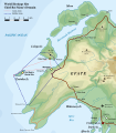
File:Map of Chief Roi Mata's Domain EN.svg
Appearance

Size of this PNG preview of this SVG file: 525 × 600 pixels. Other resolutions: 210 × 240 pixels | 420 × 480 pixels | 672 × 768 pixels | 896 × 1,024 pixels | 1,792 × 2,048 pixels | 1,400 × 1,600 pixels.
Original file (SVG file, nominally 1,400 × 1,600 pixels, file size: 215 KB)
File history
Click on a date/time to view the file as it appeared at that time.
| Date/Time | Thumbnail | Dimensions | User | Comment | |
|---|---|---|---|---|---|
| current | 19:25, 2 November 2008 |  | 1,400 × 1,600 (215 KB) | Hk kng | {{Information |Description={{en|Map of Chief Roi Mata's domain (World Heritage Site), Northwestern Efate, Vanuatu (english version)}} |Source=based on Image:Map of Efate Island RU.svg |Date= |Author= Original Map by [[User:Переход Артур|� |
File usage
Global file usage
The following other wikis use this file:
- Usage on bn.wikipedia.org
- Usage on cs.wikipedia.org
- Usage on de.wikipedia.org
- Usage on fr.wikipedia.org
- Usage on gl.wikipedia.org
- Usage on hr.wikipedia.org
- Usage on lt.wikipedia.org
- Usage on mt.wikipedia.org
- Usage on pl.wikipedia.org
- Usage on pt.wikipedia.org
- Usage on ru.wikipedia.org
- Usage on sh.wikipedia.org
- Usage on th.wikipedia.org
- Usage on tr.wikipedia.org
- Usage on vi.wikipedia.org
- Usage on zh.wikipedia.org
