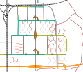
File:Map of Bijlmermeer.svg
Appearance

Size of this PNG preview of this SVG file: 696 × 600 pixels. Other resolutions: 278 × 240 pixels | 557 × 480 pixels | 891 × 768 pixels | 1,188 × 1,024 pixels | 2,376 × 2,048 pixels | 1,450 × 1,250 pixels.
Original file (SVG file, nominally 1,450 × 1,250 pixels, file size: 50 KB)
File history
Click on a date/time to view the file as it appeared at that time.
| Date/Time | Thumbnail | Dimensions | User | Comment | |
|---|---|---|---|---|---|
| current | 17:24, 28 November 2012 |  | 1,450 × 1,250 (50 KB) | IIVQ | Updated to resemble 2012-11-19 situation. Lowered road and demolished flats updated. Also, some minor cosmetic edits. |
| 21:40, 12 October 2007 |  | 1,450 × 1,250 (53 KB) | IIVQ | Previous version accidentally still had bitmap layers. Sorry | |
| 21:31, 12 October 2007 |  | 1,450 × 1,250 (55 KB) | IIVQ | {{Information |Description=Map of the Bijlmermeer in Amsterdam. Key: ;Red:Original flats standing ;Grey:Demolished flats ;Mint:Elevated roads ;Green:Renovated roads (ground level) The plane marks the site of the Bijlmer disaster. |
File usage
The following 4 pages use this file:
Global file usage
The following other wikis use this file:
- Usage on de.wikipedia.org
- Usage on es.wikipedia.org
- Usage on fi.wikipedia.org
- Usage on mk.wikipedia.org
- Usage on nl.wikipedia.org
- Usage on pt.wikipedia.org
- Usage on www.wikidata.org
