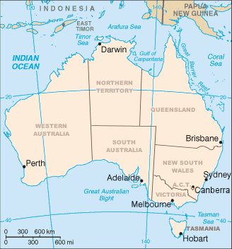
File:Map of Australia.png
Appearance
Map_of_Australia.png (328 × 352 pixels, file size: 20 KB, MIME type: image/png)
File history
Click on a date/time to view the file as it appeared at that time.
| Date/Time | Thumbnail | Dimensions | User | Comment | |
|---|---|---|---|---|---|
| current | 02:12, 10 April 2006 |  | 328 × 352 (20 KB) | Mark | Map of Australia showing the states and capital cities. Modified from a CIA World Factbook image by Mark Ryan. |
File usage
The following 13 pages use this file:
- 1900
- Geography of Australia
- Index of Australia-related articles
- List of marine animals of Australia (temperate waters)
- Luggenemenener
- United Nations Association of Australia
- User:Ambiloo/sandbox
- User:Maxmead2/sandbox
- User:Snovv
- Wikipedia:Graphics Lab/Map workshop/Archive/Dec 2011
- Template:Australia states imagemap
- Template:Australia states imagemap/sandbox
- Template:Australia states imagemap/testcases
Global file usage
The following other wikis use this file:
- Usage on an.wikipedia.org
- Usage on ar.wikipedia.org
- Usage on arz.wikipedia.org
- Usage on be-tarask.wikipedia.org
- Usage on bg.wikipedia.org
- Usage on bh.wikipedia.org
- Usage on ca.wikipedia.org
- Usage on de.wikipedia.org
- Usage on diq.wikipedia.org
- Usage on en.wikiversity.org
- Usage on es.wikipedia.org
- Usage on fo.wikipedia.org
- Usage on fr.wikipedia.org
- Usage on gl.wikipedia.org
- Usage on gom.wikipedia.org
- Usage on hi.wikipedia.org
- Usage on hu.wikipedia.org
- Usage on id.wikipedia.org
- Usage on io.wikipedia.org
- Usage on it.wikipedia.org
View more global usage of this file.


