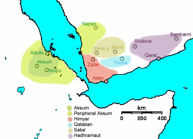
File:Map of Aksum and South Arabia ca. 230 AD.jpg
Appearance
Map_of_Aksum_and_South_Arabia_ca._230_AD.jpg (632 × 456 pixels, file size: 47 KB, MIME type: image/jpeg)
File history
Click on a date/time to view the file as it appeared at that time.
| Date/Time | Thumbnail | Dimensions | User | Comment | |
|---|---|---|---|---|---|
| current | 01:07, 14 February 2011 |  | 632 × 456 (47 KB) | Ras67 | losslessly cropped with Jpegcrop |
| 12:34, 22 October 2006 |  | 771 × 572 (68 KB) | Schreiber | {{Information| |Description= == Summary == Made by me (Yom). Map of Aksum and en:South Arabia ca. 230 AD at the end of the reign of en:GDRT. |Source= |Date= |Author=User Yom on [http://e |
File usage
The following 4 pages use this file:
Global file usage
The following other wikis use this file:
- Usage on am.wikipedia.org
- Usage on azb.wikipedia.org
- Usage on az.wikipedia.org
- Usage on ba.wikipedia.org
- Usage on be.wikipedia.org
- Usage on bg.wikipedia.org
- Usage on bn.wikipedia.org
- Usage on ca.wikipedia.org
- Usage on cs.wikipedia.org
- Usage on da.wikipedia.org
- Usage on de.wikipedia.org
- Usage on diq.wikipedia.org
- Usage on el.wikipedia.org
- Usage on en.wikibooks.org
- Usage on en.wiktionary.org
- Usage on eo.wikipedia.org
- Usage on es.wikipedia.org
- Usage on eu.wikipedia.org
- Usage on fa.wikipedia.org
- Usage on fi.wikipedia.org
- Usage on fr.wikipedia.org
View more global usage of this file.


