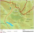
File:Map at nationalpark nockberge location.png
Appearance

Size of this preview: 622 × 599 pixels. Other resolutions: 249 × 240 pixels | 498 × 480 pixels | 740 × 713 pixels.
Original file (740 × 713 pixels, file size: 100 KB, MIME type: image/png)
File history
Click on a date/time to view the file as it appeared at that time.
| Date/Time | Thumbnail | Dimensions | User | Comment | |
|---|---|---|---|---|---|
| current | 17:03, 26 March 2006 |  | 740 × 713 (100 KB) | Mglanznig | Name of Millstätter See |
| 19:27, 18 February 2006 |  | 740 × 710 (99 KB) | Mglanznig | {{Information| |Description = de: Lage des Nationalpark Nockberge, Kärnten, en: location of national park Nockberge, Austria |Source = selbst zusammengestellt, Geodaten von http://www.demis.nl, Map24 http://at.map24.com und KAGIS http://www.kagis.ktn.gv |
File usage
The following page uses this file:
Global file usage
The following other wikis use this file:
- Usage on cs.wikipedia.org
- Usage on da.wikipedia.org
- Usage on de.wikipedia.org
- Usage on es.wikipedia.org
- Usage on et.wikipedia.org
- Usage on hu.wikipedia.org
- Usage on hy.wikipedia.org
- Usage on ro.wikipedia.org
- Usage on sk.wikipedia.org
- Usage on sl.wikipedia.org


