
File:Map Mount Tarawera 1888 with pre 1886 eruption features.gif

Size of this preview: 800 × 465 pixels. Other resolutions: 320 × 186 pixels | 640 × 372 pixels | 1,024 × 596 pixels | 1,280 × 745 pixels | 2,750 × 1,600 pixels.
Original file (2,750 × 1,600 pixels, file size: 1.77 MB, MIME type: image/gif)
| This is a file from the Wikimedia Commons. Information from its description page there is shown below. Commons is a freely licensed media file repository. You can help. |
Summary
| Description |
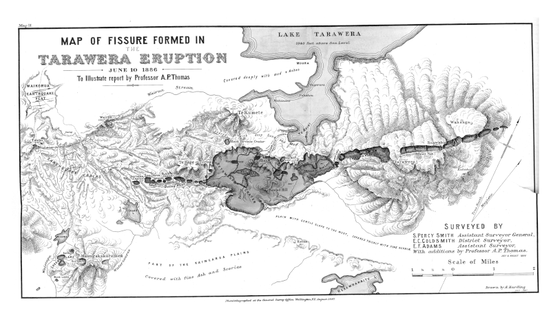
English: Map with data from official government surveyors illustrating both the chasm created by the 1886 eruption of Mount Tarawera, sizes of lakes immediate post eruption that contributed to present Lake Rotomahana and possible relationships to buried/destroyed features such as the Pink and White terraces. Also shows part of Lake Tarawera and new faults to east. Had minor alterations by Professor Thomas to the original surveyed work, including post eruption field knowledge. Some of these alterations have been analysed to be likely inaccurate as not fully consistent with Hochstetter's 1859 survey records.[1]. First published in 1888,[2] and on the internet in 2016
References
|
| Date | |
| Source | https://nzetc.victoria.ac.nz/tm/scholarly/tei-Stout68-t21-body-d1-d4.html |
| Author |
S. Percy Smith, Assistant Surveyor General E. G. Goldsmith District Surveyor E. F. Adams Assistant Surveyor A. P Thomas, Professor of Geology A Harding, Draftsman |
| Other versions | An earlier version is known to have been created and published during 1887 |
Licensing
This file is licensed under the Creative Commons Attribution-Share Alike 3.0 Unported license.
- You are free:
- to share – to copy, distribute and transmit the work
- to remix – to adapt the work
- Under the following conditions:
- attribution – You must give appropriate credit, provide a link to the license, and indicate if changes were made. You may do so in any reasonable manner, but not in any way that suggests the licensor endorses you or your use.
- share alike – If you remix, transform, or build upon the material, you must distribute your contributions under the same or compatible license as the original.
File history
Click on a date/time to view the file as it appeared at that time.
| Date/Time | Thumbnail | Dimensions | User | Comment | |
|---|---|---|---|---|---|
| current | 23:20, 16 August 2023 | | 2,750 × 1,600 (1.77 MB) | ChaseKiwi | Uploaded a work by S. Percy Smith, Assistant Surveyor General E. G. Goldsmith District Surveyor E. F. Adams Assistant Surveyor A. P Thomas, Professor of Geology A Harding, Draftsman from https://nzetc.victoria.ac.nz/tm/scholarly/tei-Stout68-t21-body-d1-d4.html with UploadWizard |
File usage
The following 4 pages use this file:
Global file usage
The following other wikis use this file:
- Usage on sl.wikipedia.org