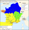
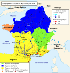
File:Map Frank campaigns in Aquitaine 507-509-fr.svg
Appearance

Size of this PNG preview of this SVG file: 577 × 599 pixels. Other resolutions: 231 × 240 pixels | 462 × 480 pixels | 740 × 768 pixels | 986 × 1,024 pixels | 1,972 × 2,048 pixels | 755 × 784 pixels.
Original file (SVG file, nominally 755 × 784 pixels, file size: 505 KB)
File history
Click on a date/time to view the file as it appeared at that time.
| Date/Time | Thumbnail | Dimensions | User | Comment | |
|---|---|---|---|---|---|
| current | 21:26, 28 January 2024 |  | 755 × 784 (505 KB) | Manlleus | fixed switch nodes for translation |
| 00:37, 27 January 2024 |  | 755 × 784 (539 KB) | Manlleus | File uploaded using svgtranslate tool (https://svgtranslate.toolforge.org/). Added translation for ca. | |
| 17:11, 6 May 2010 |  | 755 × 784 (536 KB) | Romain0 | Légende. | |
| 09:46, 1 May 2010 |  | 755 × 784 (523 KB) | Romain0 | Légendes + rivières. | |
| 09:37, 27 March 2010 |  | 755 × 784 (529 KB) | Romain0 | Légende. | |
| 20:59, 8 March 2010 |  | 755 × 784 (527 KB) | Romain0 | Taille de texte. | |
| 20:56, 8 March 2010 |  | 755 × 784 (515 KB) | Romain0 | Taille des flèches. | |
| 22:02, 6 March 2010 |  | 755 × 784 (527 KB) | Romain0 | Frontières et légendes. | |
| 20:49, 6 March 2010 |  | 755 × 784 (566 KB) | Romain0 | Légende. | |
| 20:43, 6 March 2010 |  | 755 × 784 (555 KB) | Romain0 | {{Information |Description={{fr|1=Campagnes franques en Aquitaine (507-509).}} |Source=Travail personnel sur un fond de carte hydrographique de historicair. D'après Michel Rouche, Des Wisigoths aux Arabes, l'Aquitaine 418-781 : naiss |
File usage
The following page uses this file:
Global file usage
The following other wikis use this file:
- Usage on br.wikipedia.org
- Usage on ca.wikipedia.org
- Usage on el.wikipedia.org
- Usage on eo.wikipedia.org
- Usage on es.wikipedia.org
- Usage on fr.wikipedia.org
- Usage on gl.wikipedia.org
- Usage on hu.wikipedia.org
- Usage on ka.wikipedia.org
- Usage on nl.wikipedia.org
- Usage on oc.wikipedia.org


