Jump to content

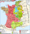
File:Map France 1180-de.svg

Page contents not supported in other languages.
This is a file from the Wikimedia Commons
From Wikipedia, the free encyclopedia

Original file (SVG file, nominally 988 × 1,124 pixels, file size: 1.94 MB)

Summary

Description
Deutsch: Karte Frankreichs im Jahr 1180
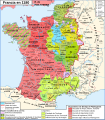
Français : Carte de la France en 1180
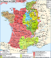
English: Map of France in 1180
Date (UTC)
Source Map France 1180-fr.svg
Author

Quellen/Sources:

  • Image:France 12thC.jpg, in William R. Shepherd, The Historical Atlas, 1911
  • Olivier Guyotjeannin, Atlas de l'histoire de France IXe-XVe siècle, Paris, 2005
  • François Menant, H. Martin, B. Merdignac & M. Chauvin, Les Capétiens - Histoire et dictionnaire 987-1328, Robert Laffont, Paris, 1999
Other versions

[edit]

SVG development
InfoField
 
The SVG code is valid.
 
This map was created with Adobe Illustrator.
 
The file size of this SVG map may be irrationally large because its text has been converted to paths inhibiting translations.
This map is a retouched picture, which means that it has been digitally altered from its original version. Modifications: traduction allemand/Deutsche Übersetzung/German translation. The original can be viewed here: Map France 1180-fr.svg. Modifications made by Furfur.

Legende

Rote Linie : Grenze des Königreichs Frankreich

 
Geistliche Herrschaften
LEHEN
AFTERLEHEN

(Datum der erstmaligen Vereinigung mit der Krondomänie) :

 
Grafschaft Flandern (1678) : Philipp I. von Flandern
durch seine Ehefrau, Elisabeth von Vermandois :
Grafschaft Vermandois (1185)
Grafschaft Amiens (1185)
Grafschaft Valois (1185)

Grafschaft Guînes (1284/1350) : Balduin II. von Guînes

Grafschaft Boulogne (1477) : Ida von Lothringen

Grafschaft Saint-Pol (1672?) : Hugo IV. de Campdavaine

Graf von Hesdin (1185?) : Philipp I. von Flandern

Grafschaft Porcéan (1284?)

Grafschaft Rethel (?) : Manassès IV de Rethel

Grafschaft Grandpré (1284?)

Herrschaft Joinville (?) : Gottfried III. von Joinville

Grafschaft Bar-sur-Aube (1284?)

Grafschaft Joigny (1284?)

Grafschaft Châteaudun (1707)

Grafschaft Chartres (1286)

Herrschaft Beaugency (1291) : Lancelin III de Beaugency

Grafschaft Auxerre (1371)

Grafschaft Tonnerre (?)

Grafschaft Chalon (1477?) : Wilhelm II. von Chalon

Grafschaft Mâcon (1239) : Gerald I. von Mâcon

Herrschaft Beaujeu (1531) : Humbert IV. von Beaujeu

Grafschaft Rouergue (1271)

Markgraftschaft Provence (1271-1791)

Vivarais (1271/1308)

Grafschaft Rodez (1589) : Hugo II. von Rodez

Grafschaft Gévaudan (1258) : Alfons II., König von Aragón

Vizegrafschaft Millau (1589?) : Alfons II., König von Aragón

Vizegrafschaft Narbonne (1507) : Ermengarde von Narbonne

Herrschaft Montpellier (1293/1349) : Wilhelm VIII. von Montpellier

Grafschaft Melgueil (1229?) : Raimund V. von Toulouse

Vizegrafschaft Agde (1229) : Bernard Aton VI. Trencavel

Vizegrafschaft Nîmes (1229) : Bernard Aton VI. Trencavel

Herrschaft Uzès (1229?) : Bermond I. d'Uzès

Grafschaft Valentinois (1446) et Diois (1404) : Adémar (Aymar) I. von Valentinois

Vizegrafschaft Albi (1229) — unter der Oberherrschaft der Grafen von Toulouse

Vizegrafschaft Béziers (1229) — unter der Oberherrschaft der Grafen von Toulouse

Vizegrafschaft Carcassonne und Razès (1229) — unter der Oberherrschaft des Königs von Aragon

Besitzungen des Hauses Plantagenêts ("Angevinisches Reich") :
Heinrich II. Plantagenêt

Grafschaft Perche (1227) : Rotrou IV. von Perche

Grafschaft Vendôme (1589) : Jean Ier de Vendôme

Comté de Coutances

Grafschaft Bayeux

Grafschaft Caux (Fécamp)

Grafschaft Rouen

Grafschaft Vexin (Vexin normand, Hauptort Gisors)

Grafschaft Alençon (1220) : Jean Ier d'Alençon

Grafschaft Aumale (1194) : Hawise d'Aumale

Vizegrafschaft Avranches (1204) : Hugh de Kevelioc, 3. Earl of Chester

Grafschaft Évreux (1200) : Simon III. von Montfort

Fürstbistum Lisieux (?) : Arnulf von Lisieux

Grafschaft Mortain (1204)

Grafschaft Eu (1350) : Heinrich II. (Eu)

Herrschaft Harcourt (?) : Robert II d'Harcourt

Grafschaft Poitou (1204/1224)

Aunis (1224)

Saintonge (1204/1375)

Grafschaft Marche (1308)

Grafschaft Poitou (1204/1224) : Eleonore von Aquitanien und Heinrich II. Plantagenêt, König von England

Vicomté de Châtellerault (1482) : Guillaume de Châtellerault

Herrschaft Lusignan (1308) : Hugo IX. von Lusignan

Herrschaft Parthenay (1415) : Guillaume IV de Parthenay-l'Archevêque

Vizegrafschaft Thouars (1469) : Aimery VII de Thouars

• Herrschaft Talmont (1469) und Fontenay (1204?) : Raoul de Mauléon ?

• Seigneurie de Montaigu (?)

Grafschaft Angoulême (1308) : Guillaume VI Taillefer

Grafschaft Périgord (1399?) : Hélie V Talleyrand

• Limousin :

Vizegrafschaft Limoges (1589) : Boson de Limoges, Adémar V. (Limoges)

Vizegrafschaft Turenne (1738) : Raimund III. von Turenne

Vizegrafschaft Ventadour (?) : Ebles IV de Ventadour

Seigneurie de Déols (1737?) : Denise de Déols

• Seigneurie d'Issoudun (XIIIe) : Eudes d'Issoudun

Comté d'Auvergne et de Clermont (Dauphiné d'Auvergne) (1525) : Robert I., Dauphin d'Auvergne

Grafschaft Auvergne (v. 1200 / 1569?) : Wilhelm (Guillaume) VIII. von Auvergne

Herrschaft Mercœur (1770) : Béraud VI de Mercœur

Vicomtés de Carlat et de Murat (1470) : Hugues II de Rodez

Herrschaft Montpensier (1531) : Agnès de Thiers und Humbert IV de Beaujeu

Seigneurie d'Albret (1589) : Amanieu IV

Vicomté de Marsan (1589) : Béatrix III de Bigorre

• Vicomté de Tursan (1589) : ?

Vicomté de Gabardan (1589) : Gaston VI de Béarn

Grafschaft Armagnac (1589) : Bernard IV d'Armagnac

Grafschaft Fézensac (1589) : Bernard IV d'Armagnac

Grafschaft Pardiac (1504) : Oger II.

Comté de Gaure (1589) : ?

• Vicomté de Lomagne (1589) : Vezian II

'Grafschaft Astarac (?) : ?

Vizegrafschaft Béarn (1589) : Gaston VI de Béarn

Grafschaft_Bigorre (1322) : Béatrix III de Bigorre

Grafschaft Comminges (1454) : Bernard IV. von Comminges

LEHEN AUSSERHALB DES KÖNIGREICHS IM JAHR 1180

Königreich Aragon

Grafschaft Barcelona

Grafschaft Roussillon (1659) : Alfons II. von Aragon

Grafschaft Provence (1498) : Raimund Berengar IV. von Provence

Comté de Forcalquier (1498) : Bertrand II de Forcalquier

Fürstentum Orange (1673-1713) : Bertrand Ier des Baux

Dauphiné du Viennois und Grafschaft Albon (1349) : Beatrix von Albon

Grafschaft Vienne (1239) : Géraud Ier de Mâcon

Herzogtum Savoyen (1860) : Humbert III von Savoyen

Grafschaft Genf (1860) : Guillaume Ier de Genève

Grafschaft Lyonnais (1312) : Domkapitel des Erzbistums Lyon

Freigrafschaft Burgund (1678) : Beatrix von Burgund et Friedrich I. Barbarossa

Herzogtum Lothringen (1766) : Simon II. von Lothringen

? Grafschaft Luxemburg (-) : Heinrich IV. von Luxemburg

Fürstbistum Lüttich (-) : Rudolf von Zähringen

? Grafschaft Namur (-) : Heinrich IV. von Luxemburg

Herzogtum Limburg (-) : Heinrich III. von Limburg

Grafschaft Hennegau (1659-1678) : Balduin V. von Hennegau

Herzogtum Brabant (Grafschaft Löwen und Brüssel, Markgrafschaft Antwerpen) : Gottfried III. von Löwen

Licensing

I, the copyright holder of this work, hereby publish it under the following licenses:
w:en:Creative Commons
attribution share alike
This file is licensed under the Creative Commons Attribution-Share Alike 3.0 Unported, 2.5 Generic, 2.0 Generic and 1.0 Generic license.
You are free:
  • to share – to copy, distribute and transmit the work
  • to remix – to adapt the work
Under the following conditions:
  • attribution – You must give appropriate credit, provide a link to the license, and indicate if changes were made. You may do so in any reasonable manner, but not in any way that suggests the licensor endorses you or your use.
  • share alike – If you remix, transform, or build upon the material, you must distribute your contributions under the same or compatible license as the original.
GNU head Permission is granted to copy, distribute and/or modify this document under the terms of the GNU Free Documentation License, Version 1.2 or any later version published by the Free Software Foundation; with no Invariant Sections, no Front-Cover Texts, and no Back-Cover Texts. A copy of the license is included in the section entitled GNU Free Documentation License.
You may select the license of your choice.

Original upload log

This image is a derivative work of the following images:

  • File:Map France 1180-fr.svg licensed with Cc-by-sa-3.0,2.5,2.0,1.0, GFDL
    • 2009-01-09T11:35:35Z Zigeuner 988x1124 (1972311 Bytes) + seigneurie de Montpensier, couleur du Velay, vicomté de Marsan
    • 2008-12-12T15:51:47Z Zigeuner 988x1124 (1970361 Bytes) Retour des limites d'arrière-fiefs dans le duché d'Aquitaine
    • 2008-12-12T14:07:15Z Zigeuner 988x1124 (1970370 Bytes) + comté d'Alençon, seigneurie d'Harcourt (Normandie)
    • 2008-12-06T15:42:18Z Zigeuner 988x1124 (1967888 Bytes) Tonnerre de la même couleur que Nevers et Auxerre
    • 2008-12-05T22:43:51Z Zigeuner 988x1124 (1967902 Bytes) Couleurs identiques pour Flandres/Vermandois/Valois
    • 2008-12-03T15:02:56Z Zigeuner 988x1124 (1966588 Bytes) {{Information |Description={{en|1=Map of the France in 1180}} {{fr|1=Carte de la France en 1180}} |Source=travail personnel (own work) |Author=[[User:Zigeuner|Zigeuner]] |Date=3 XII 2008 |Permission= |other_versions=Image:Map

Uploaded with derivativeFX

Captions

Add a one-line explanation of what this file represents

Items portrayed in this file

depicts

23 December 2011

image/svg+xml

File history

Click on a date/time to view the file as it appeared at that time.

Date/TimeThumbnailDimensionsUserComment
current22:50, 21 May 2020Thumbnail for version as of 22:50, 21 May 2020988 × 1,124 (1.94 MB)FurfurHerzogtümer -> Grafschaften, Farben etwas adaptiert
21:40, 23 August 2016Thumbnail for version as of 21:40, 23 August 2016988 × 1,124 (2.87 MB)FurfurSVG aufgeräumt, jetzt valides SVG, kleinere Dateigröße
15:23, 4 January 2012Thumbnail for version as of 15:23, 4 January 2012988 × 1,124 (3.76 MB)Furfurkleinere Korrekturen
00:11, 24 December 2011Thumbnail for version as of 00:11, 24 December 2011988 × 1,124 (3.77 MB)FurfurDetails
23:53, 23 December 2011Thumbnail for version as of 23:53, 23 December 2011988 × 1,124 (3.77 MB)Furfur== {{int:filedesc}} == {{Information |Description={{de|1=Karte Frankreichs im Jahr 1180}} {{fr|1=Carte de la France en 1180}} {{en|1=Map of the France in 1180}} |Source=*File:Map_France_1180-fr.svg |Date=2011-12-23 23:51 (UTC) |Author=*[[:File:Map_F

The following page uses this file:

Global file usage

The following other wikis use this file:

Metadata