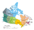
File:Map Canada political 2.png
Appearance

Size of this preview: 693 × 599 pixels. Other resolutions: 278 × 240 pixels | 555 × 480 pixels | 888 × 768 pixels | 1,184 × 1,024 pixels | 1,280 × 1,107 pixels.
Original file (1,280 × 1,107 pixels, file size: 387 KB, MIME type: image/png)
File history
Click on a date/time to view the file as it appeared at that time.
| Date/Time | Thumbnail | Dimensions | User | Comment | |
|---|---|---|---|---|---|
| current | 03:08, 7 February 2010 |  | 1,280 × 1,107 (387 KB) | Merosonox~commonswiki | {{Information |Description={{en|1=A map of Canada exhibiting its ten provinces and three territories, and their capitals.}} |Source=*File:Map_Canada_political.png |Date=2010-02-07 03:06 (UTC) |Author=*File:Map_Canada_political.png: [[:en:User: |
File usage
No pages on the English Wikipedia use this file (pages on other projects are not listed).
Global file usage
The following other wikis use this file:
- Usage on diq.wikipedia.org
- Usage on ta.wikipedia.org
- Usage on tr.wikipedia.org
- Kanada
- Şablon:Kanada'nın eyaletleri ve bölgeleri
- Manitoba
- Saskatchewan
- Ontario
- Kategori:Kanada'nın eyaletleri
- Prens Edward Adası
- New Brunswick
- Québec
- Alberta
- Yeni İskoçya
- Newfoundland ve Labrador
- Yukon
- Kuzeybatı Toprakları
- Nunavut
- Kanada'nın eyaletleri ve bölgeleri
- Kategori:Kanada'nın eyaletleri ve bölgeleri
- Kategori:Kanada'nın bölgeleri
- Banks Adası
- Britanya Kolumbiyası
- Saint-Maurice—Laflèche
