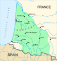
File:MapOfGascony.png
Appearance
MapOfGascony.png (484 × 513 pixels, file size: 93 KB, MIME type: image/png)
File history
Click on a date/time to view the file as it appeared at that time.
| Date/Time | Thumbnail | Dimensions | User | Comment | |
|---|---|---|---|---|---|
| current | 11:40, 9 March 2007 |  | 484 × 513 (93 KB) | Larrousiney | == Summary == {{Information |Description=Map of Gascony, South West of France |Source=Wikipedia fr |Date=09/13/2007 |Author=Larrousiney |Permission= |other_versions= }} |
| 21:43, 16 November 2006 |  | 484 × 513 (94 KB) | Mtu33260 | {{Information |Description=Map of Gascony, South West of France |Source=Wikipedia fr |Date=16/11/2006 |Author=Larrousiney |Permission= |other_versions= }} |
File usage
The following 5 pages use this file:
Global file usage
The following other wikis use this file:
- Usage on azb.wikipedia.org
- Usage on az.wikipedia.org
- Usage on cs.wikipedia.org
- Usage on da.wikipedia.org
- Usage on el.wikipedia.org
- Usage on en.wiktionary.org
- Usage on eu.wikipedia.org
- Usage on gl.wikipedia.org
- Usage on hu.wikipedia.org
- Usage on hy.wikipedia.org
- Usage on id.wikipedia.org
- Usage on ja.wikipedia.org
- Usage on ko.wikipedia.org
- Usage on ku.wikipedia.org
- Usage on lv.wikipedia.org
- Usage on no.wikipedia.org
- Usage on pl.wiktionary.org
- Usage on pt.wikipedia.org
- Usage on ro.wikipedia.org
- Usage on ru.wikipedia.org
- Usage on sh.wikipedia.org
- Usage on sk.wikipedia.org
- Usage on sl.wikipedia.org
- Usage on sr.wikipedia.org
- Usage on sv.wikipedia.org
- Usage on th.wikipedia.org
- Usage on tl.wikipedia.org
- Usage on tr.wikipedia.org
- Usage on uk.wikipedia.org
- Usage on vi.wikipedia.org
- Usage on zh.wikipedia.org


