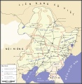
File:Manchuria Kwantung defense.svg
Appearance

Size of this PNG preview of this SVG file: 584 × 600 pixels. Other resolutions: 234 × 240 pixels | 467 × 480 pixels | 748 × 768 pixels | 997 × 1,024 pixels | 1,993 × 2,048 pixels | 914 × 939 pixels.
Original file (SVG file, nominally 914 × 939 pixels, file size: 463 KB)
File history
Click on a date/time to view the file as it appeared at that time.
| Date/Time | Thumbnail | Dimensions | User | Comment | |
|---|---|---|---|---|---|
| current | 10:47, 13 August 2010 |  | 914 × 939 (463 KB) | Tazadeperla | Correction of location name (Tachienchang - Gonghexiang). |
| 05:31, 11 August 2010 |  | 914 × 939 (463 KB) | Tazadeperla | Update of locations | |
| 04:02, 11 August 2010 |  | 914 × 939 (463 KB) | Tazadeperla | Correction of typeface errors. | |
| 03:55, 11 August 2010 |  | 914 × 939 (408 KB) | Tazadeperla | {{Information |Description={{en|1=Kwantung Army's defense plan prior to Soviet Invasion (1945), based on Glantz's maps in Levenworth Paper No 7 - Feb 1983}} |Source={{own}} |Author=Tazadeperla |Date= |Permission= |other_versions= }} |
File usage
The following 2 pages use this file:
Global file usage
The following other wikis use this file:
- Usage on vi.wikipedia.org
- Usage on zh.wikipedia.org

