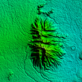
File:Malepunyo Range Relief Map.png

Original file (1,920 × 1,920 pixels, file size: 3.66 MB, MIME type: image/png)
| This is a file from the Wikimedia Commons. Information from its description page there is shown below. Commons is a freely licensed media file repository. You can help. |
Summary
| DescriptionMalepunyo Range Relief Map.png |
English: Malepunyo Range Relief Map on 1 arc second/30-meter resolution from SRTM released September 23, 2014
Rectangular Projection based on coordinates
|
||||
| Date | |||||
| Source | Own work | ||||
| Author | Ervin Malicdem | ||||
| Permission (Reusing this file) |
I, the copyright holder of this work, hereby publish it under the following licenses:
This file is licensed under the Creative Commons Attribution-Share Alike 4.0 International license.
You may select the license of your choice.
|
Initially published at Schadow1 Expeditions article http://www.s1expeditions.com/2012/12/conquering-malarayat-mountain-range.html
Captions
Items portrayed in this file
depicts
some value
9 February 2015
3,832,633 byte
1,920 pixel
1,920 pixel
image/png
22c294253d46876551b30e0a575739e73c092c54
File history
Click on a date/time to view the file as it appeared at that time.
| Date/Time | Thumbnail | Dimensions | User | Comment | |
|---|---|---|---|---|---|
| current | 05:25, 9 February 2015 |  | 1,920 × 1,920 (3.66 MB) | Schadow1 | User created page with UploadWizard |
File usage
The following page uses this file:
Metadata
This file contains additional information, probably added from the digital camera or scanner used to create or digitize it.
If the file has been modified from its original state, some details may not fully reflect the modified file.
| Software used |
|---|


