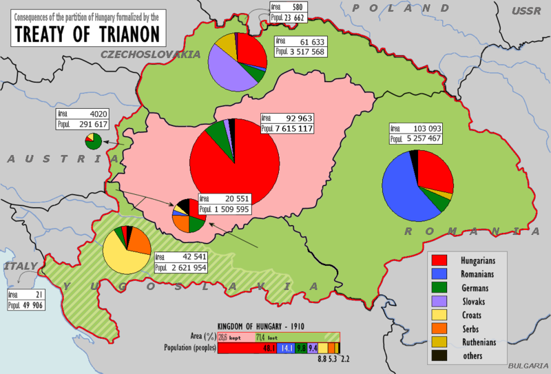
File:Magyarorszag 1920.png
Appearance

Size of this preview: 800 × 543 pixels. Other resolutions: 320 × 217 pixels | 640 × 435 pixels | 1,024 × 695 pixels | 1,140 × 774 pixels.
Original file (1,140 × 774 pixels, file size: 188 KB, MIME type: image/png)
File history
Click on a date/time to view the file as it appeared at that time.
| Date/Time | Thumbnail | Dimensions | User | Comment | |
|---|---|---|---|---|---|
| current | 12:45, 17 June 2018 |  | 1,140 × 774 (188 KB) | Julieta39 | Verified datas according with the original map [https://commons.wikimedia.org/wiki/File:Hungary1910-1920.png] distinguing areas and populations in each territory. Reverted my own mistakes. |
| 12:20, 17 June 2018 |  | 1,140 × 774 (187 KB) | Julieta39 | Uncorrupted data in today Romania's territory, according with the 1910 census and the graph. | |
| 12:04, 17 June 2018 |  | 1,140 × 774 (187 KB) | Julieta39 | Rgvis's comput is right. Magyars are the main group in Hungary. | |
| 09:57, 9 April 2018 |  | 1,140 × 774 (186 KB) | Rgvis | The latest version with uncorrupted data (as per original file) | |
| 08:11, 9 April 2018 |  | 1,140 × 774 (184 KB) | Rgvis | == {{int:filedesc}} == {{Information |Description={{be-tarask|{{w|Трыянонская мірная дамова||be-x-old}}}} {{en|w:Treaty of Trianon}} {{hu|A trianoni békeszerződés következményei}} {{sk|Následky trianonskej mierovej zmluvy}} {{cs|Následky trianonské mírové smlouvy}} {{de|Friedensvertrag von Trianon}} {{ro|Tratatul de pace de la Trianon}} The graphs have been changed for better viewing... | |
| 19:28, 1 April 2018 |  | 1,140 × 774 (172 KB) | Julieta39 | Verified Slovakia : 661 633 Magyars | |
| 19:04, 1 April 2018 |  | 1,140 × 774 (172 KB) | Julieta39 | 161 633 Magyars in Slovakia | |
| 18:32, 3 December 2017 |  | 1,140 × 774 (172 KB) | Mélomène | Cosmetic | |
| 12:24, 17 October 2017 |  | 1,140 × 774 (169 KB) | MAXHO | Contrastes | |
| 05:13, 10 October 2011 |  | 1,140 × 774 (184 KB) | 123iti | my changes: 1. Medjimurje not part of croatia, 2. Original map „Hungary1910-1920“ do not say that this is population of vojvodina |
File usage
The following 21 pages use this file:
- Aftermath of World War I
- Dissolution of Austria-Hungary
- History of Hungary
- History of Transylvania
- Hungarian irredentism
- Hungarian occupation of Yugoslav territories
- Hungarians
- Hungarians in Slovakia
- Hungary in World War II
- Interwar Hungary
- Ivo Frank
- Jobbik
- June 1920
- Kingdom of Hungary
- Lands of the Crown of Saint Stephen
- Miklós Horthy
- Revanchism
- Slovakization
- Talk:Treaty of Trianon/Archive 3
- User:Falcaorib/Austria-Hungary
- Portal:Hungary
Global file usage
The following other wikis use this file:
- Usage on af.wikipedia.org
- Usage on azb.wikipedia.org
- Usage on az.wikipedia.org
- Usage on be-tarask.wikipedia.org
- Usage on be.wikipedia.org
- Usage on bg.wikipedia.org
- Usage on bn.wikipedia.org
- Usage on br.wikipedia.org
- Usage on ca.wikipedia.org
- Usage on cs.wikipedia.org
- Usage on cy.wikipedia.org
- Usage on de.wikipedia.org
- Usage on el.wikipedia.org
- Usage on en.wiktionary.org
- Usage on eo.wikipedia.org
- Usage on es.wikipedia.org
- Usage on eu.wikipedia.org
- Usage on fa.wikipedia.org
- Usage on fr.wikipedia.org
- Usage on hr.wikipedia.org
- Usage on hu.wikipedia.org
- Usage on id.wikipedia.org
- Usage on it.wikipedia.org
View more global usage of this file.

