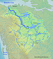
File:Mackenzierivermap.jpg
Appearance

Size of this preview: 542 × 599 pixels. Other resolutions: 217 × 240 pixels | 434 × 480 pixels | 839 × 928 pixels.
Original file (839 × 928 pixels, file size: 412 KB, MIME type: image/jpeg)
File history
Click on a date/time to view the file as it appeared at that time.
| Date/Time | Thumbnail | Dimensions | User | Comment | |
|---|---|---|---|---|---|
| current | 03:56, 5 March 2010 |  | 839 × 928 (412 KB) | Shannon1 | Added scale, etc |
| 03:52, 5 March 2010 |  | 839 × 928 (408 KB) | Shannon1 | {{Information |Description={{en|1=Map of the Mackenzie River, second greatest river in North America, that drains to the Arctic Ocean}} |Source=Background and river course data from http://www2.demis.nl/mapserver/mapper.asp, river names mostly thanks to [ |
File usage
The following 4 pages use this file:
Global file usage
The following other wikis use this file:
- Usage on af.wikipedia.org
- Usage on ar.wikipedia.org
- Usage on ast.wikipedia.org
- Usage on ba.wikipedia.org
- Usage on be-tarask.wikipedia.org
- Usage on be.wikipedia.org
- Usage on bg.wikipedia.org
- Usage on da.wikipedia.org
- Usage on el.wikipedia.org
- Usage on es.wikipedia.org
- Gran Lago del Esclavo
- Gran Lago del Oso
- Alexander MacKenzie
- Río Athabasca
- Lago Athabasca
- Río de la Paz (Canadá)
- Río de los Esclavos
- Río Finlay
- Río Liard
- Río South Nahanni
- Primeras rutas canadienses en canoa
- Río Peel (Canadá)
- Lago Claire
- Pequeño Lago de los Esclavos
- Lago Hottah
- Río Coal
- Río Omineca
- Portaje Methye
- Río Clearwater (Saskatchewan)
- Río Hay
- Río Arctic Red
- Río Pembina
- Río Dease
- Usage on fa.wikipedia.org
- Usage on he.wikipedia.org
- Usage on hr.wikipedia.org
- Usage on hu.wikipedia.org
- Usage on io.wikipedia.org
- Usage on is.wikipedia.org
- Usage on it.wikipedia.org
View more global usage of this file.

