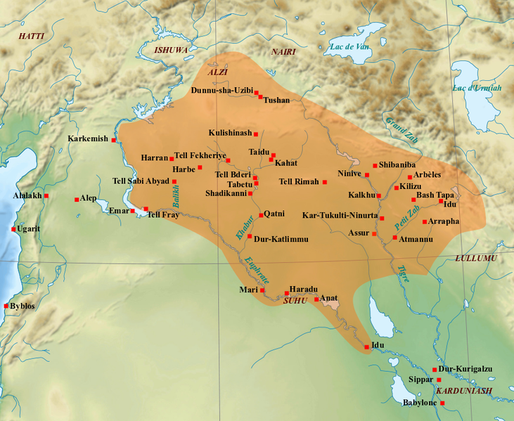
File:Médio-assyrien.png
Appearance

Size of this preview: 731 × 599 pixels. Other resolutions: 293 × 240 pixels | 586 × 480 pixels | 883 × 724 pixels.
Original file (883 × 724 pixels, file size: 724 KB, MIME type: image/png)
File history
Click on a date/time to view the file as it appeared at that time.
| Date/Time | Thumbnail | Dimensions | User | Comment | |
|---|---|---|---|---|---|
| current | 10:21, 7 March 2022 |  | 883 × 724 (724 KB) | Zunkir | ajouts et modifs |
| 20:59, 1 February 2018 |  | 883 × 724 (714 KB) | Zunkir | Nouveaux sites, tracé, localisations. | |
| 13:16, 23 September 2010 |  | 1,179 × 951 (1.6 MB) | Zunkir | Mise en couleur du royaume médio-assyrien, renommage de certains sites suivant leur nom antique. | |
| 12:48, 21 September 2010 |  | 1,263 × 888 (1.73 MB) | Zunkir | {{Information |Description={{en|1=Map of the medio-assyrian kingdom (13th-12th centuries BC).}} {{fr|1=Carte des limites approximatives du royaume médio-assyrien à son apogée (XIIIe-XIIe siècles av. J.-C.).}} |Source=*[[:File:Near_East_topographic_map |
File usage
The following 7 pages use this file:
Global file usage
The following other wikis use this file:
- Usage on ar.wikipedia.org
- Usage on bn.wikipedia.org
- Usage on ca.wikipedia.org
- Usage on cs.wikipedia.org
- Usage on de.wikipedia.org
- Usage on es.wikipedia.org
- Usage on fa.wikipedia.org
- Usage on fr.wikipedia.org
- Usage on hr.wikipedia.org
- Usage on hu.wikipedia.org
- Usage on hy.wikipedia.org
- Usage on id.wikipedia.org
- Usage on it.wikipedia.org
- Usage on ja.wikipedia.org
- Usage on ko.wikipedia.org
- Usage on lt.wikipedia.org
- Usage on nl.wikipedia.org
- Usage on pl.wikipedia.org
- Usage on pt.wikipedia.org
- Usage on ro.wikipedia.org
- Usage on ru.wikipedia.org
- Usage on sl.wikipedia.org
- Usage on ta.wikipedia.org
View more global usage of this file.

