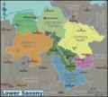
File:Lower-Saxony-map.png
Appearance

Size of this preview: 664 × 599 pixels. Other resolutions: 266 × 240 pixels | 532 × 480 pixels | 851 × 768 pixels | 1,135 × 1,024 pixels | 2,270 × 2,048 pixels | 3,032 × 2,736 pixels.
Original file (3,032 × 2,736 pixels, file size: 2.57 MB, MIME type: image/png)
File history
Click on a date/time to view the file as it appeared at that time.
| Date/Time | Thumbnail | Dimensions | User | Comment | |
|---|---|---|---|---|---|
| current | 12:57, 25 October 2016 |  | 3,032 × 2,736 (2.57 MB) | Ypsilon from Finland | + Frame to prevent roads etc. overflowing the maps borders |
| 13:08, 24 October 2016 |  | 3,525 × 2,907 (2.65 MB) | Ypsilon from Finland | Regions rearranged per voy:Talk:Lower Saxony | |
| 19:39, 26 January 2013 |  | 3,000 × 2,707 (2.57 MB) | Globe-trotter | {{Information |Description ={{en|1=Travel map of Lower Saxony.}} |Source ={{own}} based on OpenStreetMap.org [http://openstreetmap.org]; regions traced from Lower saxony template.png by [[Wikipedia:de:Benu... |
File usage
The following page uses this file:
Global file usage
The following other wikis use this file:
- Usage on de.wikivoyage.org
- Usage on el.wikivoyage.org
- Usage on en.wikivoyage.org
- Usage on fa.wikipedia.org
- Usage on fi.wikivoyage.org
- Usage on he.wikivoyage.org
- Usage on it.wikivoyage.org
- Usage on ru.wikivoyage.org
- Usage on tl.wikipedia.org
