
File:London High Holborn geograph-3083817-by-Ben-Brooksbank.jpg
Size of this preview: 800 × 480 pixels. Other resolutions: 320 × 192 pixels | 898 × 539 pixels.
Original file (898 × 539 pixels, file size: 194 KB, MIME type: image/jpeg)
| This is a file from the Wikimedia Commons. Information from its description page there is shown below. Commons is a freely licensed media file repository. You can help. |
Summary
| Description |
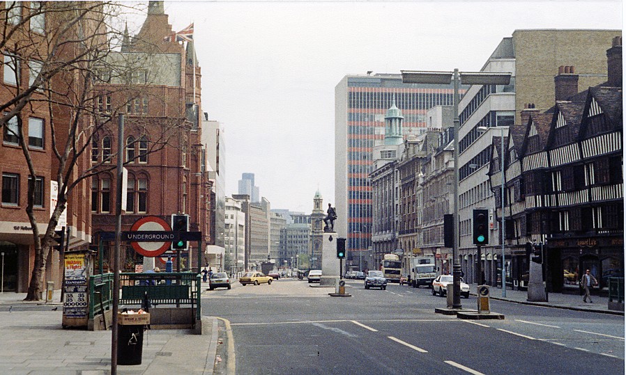
English: Eastward along High Holborn at corner of Grays Inn Road. View from the eastern exit of Chancery Lane Underground station. Grays Inn Road is on the left, Staple Inn (dating from 1585) on the right, Holborn Circus, Holborn Viaduct and much else ahead. |
| Date | |
| Source | From geograph.org.uk |
| Author | Ben Brooksbank |
| Permission (Reusing this file) |
Creative Commons Attribution Share-alike license 2.0 |
| Camera location | | View this and other nearby images on: OpenStreetMap |
|---|
Licensing

|
This image was taken from the Geograph project collection. See this photograph's page on the Geograph website for the photographer's contact details. The copyright on this image is owned by Ben Brooksbank and is licensed for reuse under the Creative Commons Attribution-ShareAlike 2.0 license.
|
This file is licensed under the Creative Commons Attribution-Share Alike 2.0 Generic license.
Attribution: Ben Brooksbank
- You are free:
- to share – to copy, distribute and transmit the work
- to remix – to adapt the work
- Under the following conditions:
- attribution – You must give appropriate credit, provide a link to the license, and indicate if changes were made. You may do so in any reasonable manner, but not in any way that suggests the licensor endorses you or your use.
- share alike – If you remix, transform, or build upon the material, you must distribute your contributions under the same or compatible license as the original.
File history
Click on a date/time to view the file as it appeared at that time.
| Date/Time | Thumbnail | Dimensions | User | Comment | |
|---|---|---|---|---|---|
| current | 18:42, 17 August 2012 | | 898 × 539 (194 KB) | Chevin | == {{int:filedesc}} == {{Information |Description={{en|1='''Eastward along High Holborn at corner of Grays Inn Road.'''<br/> View from the eastern exit of Chancery Lane Underground station. Grays Inn Road is on the left, Staple Inn (dating from 1585) o... |
File usage
The following page uses this file:
Global file usage
The following other wikis use this file:
- Usage on ar.wikipedia.org
- Usage on azb.wikipedia.org
- Usage on pl.wikipedia.org