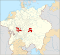
File:Locator Electoral Palatinate within the Holy Roman Empire (1618).svg
Appearance

Size of this PNG preview of this SVG file: 658 × 600 pixels. Other resolutions: 263 × 240 pixels | 527 × 480 pixels | 843 × 768 pixels | 1,123 × 1,024 pixels | 2,247 × 2,048 pixels | 2,769 × 2,524 pixels.
Original file (SVG file, nominally 2,769 × 2,524 pixels, file size: 1 MB)
File history
Click on a date/time to view the file as it appeared at that time.
| Date/Time | Thumbnail | Dimensions | User | Comment | |
|---|---|---|---|---|---|
| current | 00:55, 28 January 2015 |  | 2,769 × 2,524 (1 MB) | Sir Iain | Corrected Bohemian border |
| 14:24, 27 January 2015 |  | 2,769 × 2,524 (1,018 KB) | Sir Iain | Corrected mistake in Bohemia | |
| 14:19, 22 January 2015 |  | 2,769 × 2,524 (1,022 KB) | Sir Iain | Redone Schleswig-Holstein | |
| 00:53, 5 January 2015 |  | 2,769 × 2,524 (998 KB) | Sir Iain | Savoy shown as core territory of the HRR | |
| 20:27, 23 December 2014 |  | 2,769 × 2,524 (998 KB) | Sir Iain | Removed the Imperial border between Germany and the Netherlands | |
| 01:18, 23 December 2014 |  | 2,769 × 2,524 (1,002 KB) | Sir Iain | User created page with UploadWizard |
File usage
The following 3 pages use this file:
Global file usage
The following other wikis use this file:
- Usage on af.wikipedia.org
- Usage on ar.wikipedia.org
- Usage on ast.wikipedia.org
- Usage on az.wikipedia.org
- Usage on bg.wikipedia.org
- Usage on cs.wikipedia.org
- Usage on fa.wikipedia.org
- Usage on fr.wikipedia.org
- Usage on fy.wikipedia.org
- Usage on it.wikipedia.org
- Usage on ko.wikipedia.org
- Usage on nl.wikipedia.org
- Usage on ru.wikipedia.org
- Usage on simple.wikipedia.org
- Usage on sr.wikipedia.org
- Usage on tr.wikipedia.org
- Usage on uk.wikipedia.org
- Usage on www.wikidata.org
