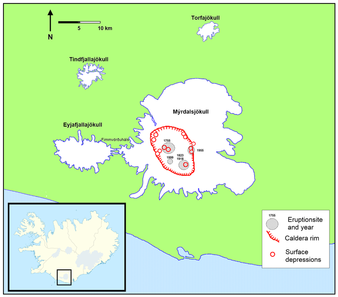
File:Location of Katlas caldera.png
Appearance

Size of this preview: 683 × 600 pixels. Other resolutions: 273 × 240 pixels | 547 × 480 pixels | 875 × 768 pixels | 1,166 × 1,024 pixels | 1,769 × 1,553 pixels.
Original file (1,769 × 1,553 pixels, file size: 229 KB, MIME type: image/png)
File history
Click on a date/time to view the file as it appeared at that time.
| Date/Time | Thumbnail | Dimensions | User | Comment | |
|---|---|---|---|---|---|
| current | 20:33, 30 August 2010 |  | 1,769 × 1,553 (229 KB) | RicHard-59 | Added location of 1999 eruption based on image on [http://pics.livejournal.com/michaelbix/pic/0001db5b pics.livejournal.com] |
| 07:45, 29 May 2010 |  | 1,769 × 1,553 (228 KB) | RicHard-59 | The glaciers: more details; caldera rim more precise; eruption sites; surface depression-sites | |
| 08:48, 27 April 2010 |  | 724 × 500 (69 KB) | RicHard-59 | {{Information |Description={{en|1=Partly enlarged section: shows the area of Mýrdalsjökull-glacier with estimated location of the caldera of Katla-volcano. Location is based on this [http://www.raunvis.hi.is/~mtg/pdf/Jokull49_HBetal_Myrdalsjokull.pdf st |
File usage
The following page uses this file:
Global file usage
The following other wikis use this file:
- Usage on bn.wikipedia.org
- Usage on cs.wikipedia.org
- Usage on de.wikipedia.org
- Usage on es.wikipedia.org
- Usage on fi.wikipedia.org
- Usage on hy.wikipedia.org
- Usage on is.wikipedia.org
- Usage on ky.wikipedia.org
- Usage on mk.wikipedia.org
- Usage on pl.wikipedia.org
- Usage on ro.wikipedia.org
- Usage on sl.wikipedia.org
- Usage on sv.wikipedia.org

