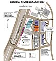
File:LocationMap.jpg
Appearance
LocationMap.jpg (493 × 599 pixels, file size: 106 KB, MIME type: image/jpeg)
File history
Click on a date/time to view the file as it appeared at that time.
| Date/Time | Thumbnail | Dimensions | User | Comment | |
|---|---|---|---|---|---|
| current | 17:41, 10 February 2011 |  | 493 × 599 (106 KB) | Alemap3 | changed pixel size |
| 21:14, 9 February 2011 |  | 493 × 539 (99 KB) | Alemap3 | Changed picture from dark to light | |
| 21:08, 9 February 2011 |  | 1,700 × 2,200 (474 KB) | Alemap3 | {{Information |Description ={{en|1=Detailed map of the immediate Eisemann Center area}} |Source =Eisemann Center, City of Richardson |Author =Eisemann Center, City of Richardson |Date =2002 |Permission =Full permission gra |
File usage
The following page uses this file:

