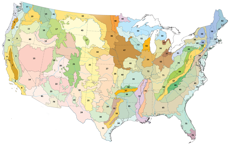
File:Level III ecoregions, United States.png
Appearance

Size of this preview: 800 × 506 pixels. Other resolutions: 320 × 202 pixels | 640 × 405 pixels | 1,024 × 648 pixels | 1,600 × 1,012 pixels.
Original file (1,600 × 1,012 pixels, file size: 791 KB, MIME type: image/png)
File history
Click on a date/time to view the file as it appeared at that time.
| Date/Time | Thumbnail | Dimensions | User | Comment | |
|---|---|---|---|---|---|
| current | 07:58, 19 June 2008 |  | 1,600 × 1,012 (791 KB) | Northwest-historian | {{Information |Description={{en|1=Level III ecoregions in the Pacific Northwest, as defined by the U.S. Environmental Protections Agency }} |Source=Modified from US EPA map at [http://www.epa.gov/wed/pages/ecoregions/level_iii.htm] |Author=U.S. Environmen |
File usage
The following 6 pages use this file:
Global file usage
The following other wikis use this file:
- Usage on bg.wikipedia.org
- Среден Царевичен пояс
- Южна крайбрежна равнина
- Югозападни Апалачи
- Средни Апалачи
- Средни Велики равнини
- Флинт Хилс
- Северен Пидмънт
- Източноголемоезерна низина
- Югоизточни равнини
- Атлантически борови крайбрежни низини
- Западно Алигейнско плато
- Акадски равнини и хълмове
- Вътрешни речни долини и хълмове
- Вътрешно плато
- Североизточна крайбрежна зона
- Льосови равнини на Мисисипската долина
- Пайни Удс
- Северни централни широколистни гори
- Източни среднотексаски равнини
- Извънледникова зона
- Usage on cs.wikipedia.org
- Usage on de.wikipedia.org
- Usage on eo.wikipedia.org
- Usage on fr.wikipedia.org
- Usage on ru.wikipedia.org
- Usage on sv.wikipedia.org
- Usage on uk.wikipedia.org
- Usage on www.wikidata.org


