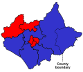
File:LeicestershireRutlandParliamentaryConstituency2005Results.svg
Appearance

Size of this PNG preview of this SVG file: 244 × 203 pixels. Other resolutions: 289 × 240 pixels | 577 × 480 pixels | 923 × 768 pixels | 1,231 × 1,024 pixels | 2,462 × 2,048 pixels.
Original file (SVG file, nominally 244 × 203 pixels, file size: 52 KB)
File history
Click on a date/time to view the file as it appeared at that time.
| Date/Time | Thumbnail | Dimensions | User | Comment | |
|---|---|---|---|---|---|
| current | 18:57, 17 December 2019 |  | 244 × 203 (52 KB) | The- | Cropped |
| 23:07, 26 January 2019 |  | 250 × 215 (57 KB) | The- | Fixed colours. | |
| 00:54, 4 May 2010 |  | 250 × 215 (57 KB) | Wereon | Rutland | |
| 00:37, 4 May 2010 |  | 200 × 215 (54 KB) | Wereon | == {{int:filedesc}} == Map of Parliamentary constituencies in Leicestershire and Rutland, showing the results by party in the general election of 2005. == {{int:license}} == {{PD-self}} [[Category:Locator maps of parliamentary constituencies of Leiceste |
File usage
The following 2 pages use this file:
Global file usage
The following other wikis use this file:
- Usage on fr.wikipedia.org
