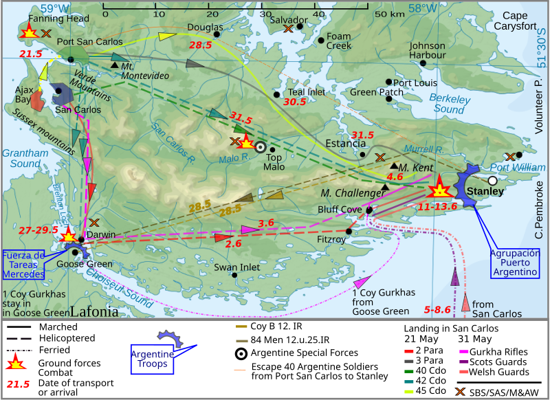
File:Land.ops.2.en.svg
Appearance

Size of this PNG preview of this SVG file: 800 × 581 pixels. Other resolutions: 320 × 233 pixels | 640 × 465 pixels | 1,024 × 744 pixels | 1,280 × 930 pixels | 2,560 × 1,860 pixels | 940 × 683 pixels.
Original file (SVG file, nominally 940 × 683 pixels, file size: 1.42 MB)
File history
Click on a date/time to view the file as it appeared at that time.
| Date/Time | Thumbnail | Dimensions | User | Comment | |
|---|---|---|---|---|---|
| current | 10:40, 26 March 2012 |  | 940 × 683 (1.42 MB) | Brammers | Spelling change: Marsh > Marched |
| 19:47, 1 November 2010 |  | 940 × 683 (1.42 MB) | Keysanger | {{Information |Description={{en|The '''Falkland Islands''' are an archipelago in the South Atlantic Ocean}} |Source=*File:Falkland_Islands_topographic_map-en.svg |Date=2010-11-01 19:44 (UTC) |Author=*[[:File:Falkland_Islands_topographic_map-en.s |
File usage
The following 2 pages use this file:
Global file usage
The following other wikis use this file:
- Usage on fy.wikipedia.org
- Usage on he.wikipedia.org
- Usage on lt.wikipedia.org
- Usage on pl.wikipedia.org
- Usage on ro.wikipedia.org
- Usage on ru.wikipedia.org
- Usage on zh.wikipedia.org

