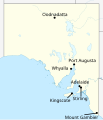
File:Labelled map of South Australia for Climate of Australia article.svg
Appearance

Size of this PNG preview of this SVG file: 516 × 599 pixels. Other resolutions: 207 × 240 pixels | 413 × 480 pixels | 661 × 768 pixels | 882 × 1,024 pixels | 1,763 × 2,048 pixels | 1,535 × 1,783 pixels.
Original file (SVG file, nominally 1,535 × 1,783 pixels, file size: 322 KB)
File history
Click on a date/time to view the file as it appeared at that time.
| Date/Time | Thumbnail | Dimensions | User | Comment | |
|---|---|---|---|---|---|
| current | 19:35, 9 January 2020 |  | 1,535 × 1,783 (322 KB) | Fuse809 | Labels are small compared to my other map's labels, so increasing their font size |
| 15:37, 8 January 2020 |  | 1,535 × 1,783 (321 KB) | Fuse809 | Border Village doesn't have any weather data on bom.gov.au, so rm | |
| 15:34, 8 January 2020 |  | 1,535 × 1,783 (322 KB) | Fuse809 | Adding Border Village and Kingscote; Border Village is a fair way away from the other towns, hence probably worth including. Kingscote might be worth adding due to the fact that unlike the others it is on an island and islands tend to have more moderate weather. | |
| 00:41, 8 January 2020 |  | 1,535 × 1,783 (320 KB) | Fuse809 | User created page with UploadWizard |
File usage
The following page uses this file:
